Mare Tyrrhenum quadrangle
| Mare Tyrrhenum quadrangle | |
|---|---|
 Map of Mare Tyrrhenum quadrangle from Mars Orbiter Laser Altimeter (MOLA) data. The highest elevations are red and the lowest are blue. | |
| Coordinates | 15°00′S 247°30′W / 15°S 247.5°WCoordinates: 15°00′S 247°30′W / 15°S 247.5°W |

The Mare Tyrrhenum quadrangle is one of a series of 30 quadrangle maps of Mars used by the United States Geological Survey (USGS) Astrogeology Research Program. The Mare Tyrrhenum quadrangle is also referred to as MC-22 (Mars Chart-22).[1]
The Mare Tyrrhenum quadrangle covers the area from 225° to 270° west longitude and 0° to 30° south latitude on Mars. Schiaparelli named the area after Earth's Tyrrhenian Sea, which lies between Italy and Sicily. The region was subsequently renamed to Mare Tyrrhena after spacecraft photos revealed that it is an old, cratered plain rather than a sea. It contains the large volcano Tyrrhenus Mons, one of the oldest, and perhaps the most complex volcanoes on Mars.[2][3] Mare Tyrrhenum's largest crater is Herschel. Licus Vallis and the Ausonia Montes are other major features in the region.
Fossa on Mars
Large troughs (long narrow depressions) are called fossae in the geographical language used for Mars. Troughs form when the crust is stretched until it breaks. The stretching can be due to the large weight of a nearby volcano. Fossae/pit craters are common near volcanoes in the Tharsis and Elysium system of volcanoes.[4] A trough often has two breaks with a middle section moving down, leaving steep cliffs along the sides; such a trough is called a graben.[5] Lake George, in northern New York State, is a lake that sits in a graben. Studies have found that on Mars a fault may be as deep as 5 km, that is the break in the rock goes down to 5 km. Moreover, the crack or fault sometimes widens or dilates. This widening causes a void to form with a relatively high volume. When material slides into the void, a pit crater or a pit crater chain forms. Pit craters do not have rims or ejecta around them, like impact craters do. On Mars, individual pit craters can join to form chains or even to form troughs that are sometimes scalloped.[6] Other ideas have been suggested for the formation of fossae and pit craters. There is evidence that they are associated with dikes of magma. Magma might move along, under the surface, breaking the rock and more importantly melting ice. The resulting action would cause a crack to form at the surface. Pit craters are not common on Earth. Sinkholes, where the ground falls into a hole (sometimes in the middle of a town) resemble pit craters on Mars. However, on the Earth these holes are caused by limestone being dissolved thereby causing a void.[6][7][8] Tyrrhenus Mons has some beautiful fossae and pit craters associated with it. These features are easily visible in the gallery image below, obtained by HiRISE.
Knowledge of the locations and formation mechanisms of pit craters and fossae is important for the future colonization of Mars because they may be reservoirs of water.[9]
Craters
-
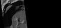
Depression on crater floor, as seen by HiRISE under HiWish program. This scene is enlarged in the next two images.
-
Close-up of depression on crater floor, as seen by HiRISE under HiWish program.
-

Close-up of west edge of crater depression, as seen by HiRISE under HiWish program.
-

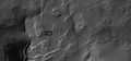
Kinkora Crater Rim, as seen by HiRISE. A beautiful shadow effect is visible.
Some Features of Mare Tyrrhenum quadrangle
-
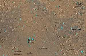
Map of Mare Tyrrhenum quadrangle. Tyrrhenus Mons is a major volcano.
-

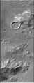
Lave flow, as seen by THEMIS. Note the shape of the edges
-
The Ausonia Montes in Mare Tyrrhenum as seen by CTX.
-

Tyrrhenus Mons, as seen by HiRISE and suggested by Ehsan Sanaei's high school astronomy club in Yazd, Iran. Click on image to see excellent view of pit crater chains and concentric features around a volcano.
-

Licus Vallis, as seen by HiRISE.
-

Small meandering channel in the stream bed of a larger channel. Water probably eroded the two channels at different times. Image from HiRISE under the HiWish program.
-

Channel in Ausonia Mensa, as seen by HiRISE under the HiWish program.
See also
- Fossa (geology)
- Geology of Mars
- Impact crater
- List of quadrangles on mars
- Vallis
References
- ↑ Davies, M.E.; Batson, R.M.; Wu, S.S.C. “Geodesy and Cartography” in Kieffer, H.H.; Jakosky, B.M.; Snyder, C.W.; Matthews, M.S., Eds. Mars. University of Arizona Press: Tucson, 1992.
- ↑ Hartmann, W. 2003. A Traveler's Guide to Mars. Workman Publishing. NY NY.
- ↑ Michael H. Carr (2006). The surface of Mars. Cambridge University Press. ISBN 978-0-521-87201-0. Retrieved 21 March 2011.
- ↑ Skinner, J., L. Skinner, and J. Kargel. 2007. Re-assessment of Hydrovolcanism-based Resurfacing within the Galaxias Fossae Region of Mars. Lunar and Planetary Science XXXVIII (2007)
- ↑ http://hirise.lpl.arizona.edu/PSP_008641_2105
- ↑ 6.0 6.1 Wyrick, D., D. Ferrill, D. Sims, and S. Colton. 2003. Distribution, Morphology and Structural Associations of Martian Pit Crater Chains. Lunar and Planetary Science XXXIV (2003)
- ↑ http://www.swri.edu/4org/d20/DEMPS/planetgeo/planetmars.html
- ↑ http://www.msss.com/mars_images/moc/2004/01/29/index.html
- ↑ Ferrill, D., D. Wyrick, A. Morris, D. Sims, and N. Franklin. 2004. Dilational fault slip and pit chain foramtion on Mars 14:10:4-12


| Quadrangles on Mars | |||||||||||||||||||||||
|---|---|---|---|---|---|---|---|---|---|---|---|---|---|---|---|---|---|---|---|---|---|---|---|
| MC-01 Mare Boreum (features) | |||||||||||||||||||||||
| MC-05 Ismenius Lacus (features) |
MC-06 Casius (features) |
MC-07 Cebrenia (features) |
MC-02 Diacria (features) |
MC-03 Arcadia (features) |
MC-04 Acidalium (features) | ||||||||||||||||||
| MC-12 Arabia (features) |
MC-13 Syrtis Major (features) |
MC-14 Amenthes (features) |
MC-15 Elysium (features) |
MC-08 Amazonis (features) |
MC-09 Tharsis (features) |
MC-10 Lunae Palus (features) |
MC-11 Oxia Palus (features) | ||||||||||||||||
| MC-20 Sinus Sabaeus (features) |
MC-21 Iapygia (features) |
MC-22 Mare Tyrrhenum (features) |
MC-23 Aeolis (features) |
MC-16 Memnonia (features) |
MC-17 Phoenicis Lacus (features) |
MC-18 Coprates (features) |
MC-19 Margaritifer Sinus (features) | ||||||||||||||||
| MC-27 Noachis (features) |
MC-28 Hellas (features) |
MC-29 Eridania (features) |
MC-24 Phaethontis (features) |
MC-25 Thaumasia (features) |
MC-26 Argyre (features) | ||||||||||||||||||
| MC-30 Mare Australe (features) | |||||||||||||||||||||||
