Marchirolo
From Wikipedia, the free encyclopedia
| Marchirolo | |
|---|---|
| Comune | |
| Comune di Marchirolo | |
 Marchirolo | |
| Coordinates: 45°57′N 8°49′E / 45.950°N 8.817°ECoordinates: 45°57′N 8°49′E / 45.950°N 8.817°E | |
| Country | Italy |
| Region | Lombardy |
| Province | Province of Varese (VA) |
| Area | |
| • Total | 5.5 km2 (2.1 sq mi) |
| Elevation | 500 m (1,600 ft) |
| Population (Dec. 2004) | |
| • Total | 3,355 |
| • Density | 610/km2 (1,600/sq mi) |
| Demonym | Marchirolesi |
| Time zone | CET (UTC+1) |
| • Summer (DST) | CEST (UTC+2) |
| Postal code | 21030 |
| Dialing code | 0332 |
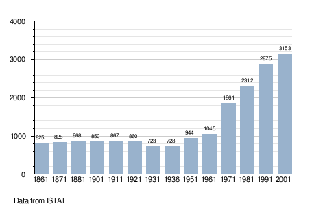
Marchirolo is a comune (municipality) in the Province of Varese in the Italian region Lombardy, located about 60 km northwest of Milan and about 15 km north of Varese. As of 31 December 2004, it had a population of 3,355 and an area of 5.5 km².[1]
Marchirolo borders the following municipalities: Cadegliano-Viconago, Cuasso al Monte, Cugliate-Fabiasco, Marzio.
Demographic evolution
References
This article is issued from Wikipedia. The text is available under the Creative Commons Attribution/Share Alike; additional terms may apply for the media files.