Mangaldan, Pangasinan
From Wikipedia, the free encyclopedia
| Mangaldan Baley na Mangaldan | ||
|---|---|---|
| Municipality | ||
 | ||
| ||
 | ||
.svg.png) Mangaldan | ||
| Coordinates: 16°04′N 120°24′E / 16.067°N 120.400°ECoordinates: 16°04′N 120°24′E / 16.067°N 120.400°E | ||
| Country |
| |
| Region | Ilocos (Region I) | |
| Province | Pangasinan | |
| District | 4th district of Pangasinan | |
| Barangays | 31 | |
| Government[1] | ||
| • Mayor | Bona Fe De Vera Parayno | |
| Area[2] | ||
| • Total | 48.47 km2 (18.71 sq mi) | |
| Population (2010)[3] | ||
| • Total | 98,905 | |
| • Density | 2,000/km2 (5,300/sq mi) | |
| Time zone | PST (UTC+8) | |
| ZIP code | 2432 | |
| Dialing code | 75 | |
| Income class | 1st class | |
| Website | www.mangaldan.gov.ph | |

Mangaldan (Pangasinan: Baley na Mangaldan) is a first class municipality in the province of Pangasinan, Philippines. It is near Dagupan City. It is in the 4th congressional district of Pangasinan. According to the 2010 census, it has a population of 98,905 people.[3]
Mangaldan was founded by Dominican order missionaries from Spain (the third such city in Pangasinan). It is known to have already been a Spanish encomienda by 1591. During World War II, Mangaldan had an airstrip that was used by the American military.
Barangays
Mangaldan is politically subdivided into 30 barangays.[2]
- Alitaya
- Amansabina
- Anolid
- Banaoang
- Bantayan
- Bari
- Bateng
- Buenlag
- David
- Embarcadero
- Gueguesangen
- Guesang
- Guiguilonen
- Guilig
- Inlambo
- Lanas
- Landas
- Maasin
- Macayug
- Malabago
- Navaluan
- Nibaliw
- Osiem
- Palua
- Poblacion
- Pogo
- Salaan
- Salay
- Tebag
- Talogtog
Demographics
| Population census of Mangaldan | ||
|---|---|---|
| Year | Pop. | ±% p.a. |
| 1990 | 65,947 | — |
| 1995 | 73,351 | +2.15% |
| 2000 | 82,142 | +2.29% |
| 2007 | 90,391 | +1.38% |
| 2010 | 98,905 | +3.05% |
| Source: National Statistics Office[3][4] | ||
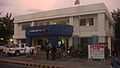
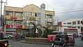
Images
-

Welcome sign
-

Centro and the Municipal Building
-

Town hall
-

Vicariate of Sto. Tomas de Aquino, Parish of St. Thomas Aquinas
-
Police Station
-
Junction, crossing
References
- ↑ "Official City/Municipal 2013 Election Results". Intramuros, Manila, Philippines: Commission on Elections (COMELEC). 1 July 2013. Retrieved 5 September 2013.
- ↑ 2.0 2.1 "Province: PANGASINAN". PSGC Interactive. Makati City, Philippines: National Statistical Coordination Board. Retrieved 26 November 2012.
- ↑ 3.0 3.1 3.2 "Total Population by Province, City, Municipality and Barangay: as of May 1, 2010". 2010 Census of Population and Housing. National Statistics Office. Retrieved 26 November 2012.
- ↑ "Province of Pangasinan". Municipality Population Data. LWUA Research Division. Retrieved 5 September 2013.
External links
| Wikimedia Commons has media related to Mangaldan. |
- Municipality Homepage
- Mangalda Official LGU Website
- Philippine Standard Geographic Code
- Philippine Census Information
- Local Governance Performance Management System
- RESIDENCIA SAN JOSE
 |
San Fabian | | ||
| Dagupan | |
San Jacinto | ||
| ||||
| | ||||
| Calasiao | Santa Barbara | Mapandan |
| |||||||||||
This article is issued from Wikipedia. The text is available under the Creative Commons Attribution/Share Alike; additional terms may apply for the media files.