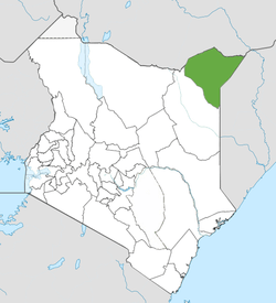
Mandera County
From Wikipedia, the free encyclopedia
Not to be confused with Mandera.
| Mandera County | |
|---|---|
| County | |
 | |
| Country |
|
| Formed | March 4th 2013 |
| Capital | Mandera |
| Government | |
| • Governor | Ali Roba |
| Area | |
| • Total | 25,797.7 km2 (9,960.5 sq mi) |
| Population (2009) | |
| • Total | 1,025,756 [1] |
| Time zone | EAT (UTC+3) |
Mandera County is a county in the former North Eastern Province of Kenya. Its capital and largest town is Mandera. The county has a population of 1,025,756 (2009 census) [2] and an area of 25,797.7 km².
| Local authorities (councils) | ||||
| Authority | Type | Population* | Urban pop.* | |
|---|---|---|---|---|
| Mandera | Town | 39,697 | 30,433 | |
| Mandera County | County | 210,675 | 22,505 | |
| Total | - | 250,372 | 52,938 | |
| * 1999 census. Source: | ||||
| Administrative divisions | |||||||||
| Division | Population* | Pop. density* | Area (km²) | Headquarters | |||||
|---|---|---|---|---|---|---|---|---|---|
| Ashabito | 33,034 | 7 | x | Rhamu | |||||
| Banisa | 38,411 | 27 | x | Banissa | |||||
| Central | 43,916 | 437 | x | Mandera | |||||
| Dandu | 16,534 | 8 | x | Takaba | |||||
| El Wak | 16,391 | 26 | x | El Wak | |||||
| Fino | 7,910 | 4 | x | Lafey | |||||
| Hareri | 5,468 | 5 | x | Mandera | |||||
| Khalalio | 7,948 | 16 | x | Mandera | |||||
| Kotulo | 12,955 | 5 | x | Elwak | |||||
| Lafey | 7,865 | 9 | x | Lafey | |||||
| Libehia | 2,992 | 4 | x | Mandera | |||||
| Malkamari | 12,498 | 7 | x | Mandera | |||||
| Rahamu Dimtu | 7,371 | 8 | x | Rhamu | |||||
| Rhamu | 10,818 | 75 | x | Rhamu | |||||
| Shimbir Fatuma | 5,179 | 3 | x | Elwak | |||||
| Takaba | 9,668 | 3 | x | Takaba | |||||
| Warankara | 3,042 | 3 | x | Lafey | |||||
| Wargadud | 8,372 | 8 | x | Elwak | |||||
| Sala | 4,322 | 5 | x | Lafey | |||||
| Kiliweri | 7,572 | 9 | x | Banisa | Total | 250,372 | 9 (average) | x | - |
| * 1999 census. Sources: | |||||||||
The county has three constituencies:
- Mandera South Constituency
- Mandera West Constituency
- Mandera East Constituency
- Mandera North Constituency
- Banisa Constituency
- Lafey Constituency
See also
- Mombasa County
- Kwale County
- Kilifi County
- Tana River County
- Lamu County
- Taita Taveta County
- Garissa County
- Wajir County
- Mandera County
- Marsabit County
- Isiolo County
- Meru County
- Tharaka Nithi County
- Embu County
- Kitui County
- Machakos County
- Makueni County
- Nyandarua County
- Nyeri County
- Kirinyaga County
- Muranga County
- Kiambu County
- Turkana County
- West Pokot County
- Samburu County
- Trans Nzoia County
- Uasin Gishu County
- Elgeyo Marakwet County
- Nandi County
- Baringo County
- Laikipia County
- Nakuru County
- Narok County
- Kajiado County
- Kericho County
- Bomet County
- Kakamega County
- Vihiga County
- Bungoma County
- Busia County
- Siaya County
- Kisumu County
- Homa Bay County
- Migori County
- Kisii County
- Nyamira County
- Nairobi County
References
External links
- http://softkenya.com/county/mandera-county/ Mandela County
- Map of the District
- http://www.reliefweb.int/rw/RWB.NSF/db900SID/VBOL-6UEDLF?OpenDocument
- http://www.aridland.go.ke/districts.asp?DistrictID=9
Coordinates: 3°25′00″N 40°40′00″E / 3.41667°N 40.6667°E
This article is issued from Wikipedia. The text is available under the Creative Commons Attribution/Share Alike; additional terms may apply for the media files.