Malpaís (landform)
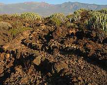
A malpaís is a landform characterized by eroded rocks of volcanic origin in an arid environment. This describes many xeric places, but is strongly connected to Spanish-speaking countries and the Southwestern United States because of the Spanish settlers that gave the landform its name.
Badlands landform
The word 'malpaís' in Spanish translates to "badland", and this describes the area as being unusable for crops. Although a malpaís is often another word for the badlands that form by erosion of sedimentary rocks in the same environment, a malpaís is also often associated with such types of lava plain terrain as found in a volcanic field. The geology of malpaís terrain is bare to thin layers of soil over lava with sparse vegetation. The lava fields usually consist of lava tube cave systems, sinkholes, pyroclastic deposits from cinder cone volcanoes, ʻaʻā and pāhoehoe lava flows. The lava tubes can vary from intact caves to partial or completely collapsed passages. The collapsed tubes, sinkholes, and jagged ʻaʻā surfaces are what make malpaís terrain so difficult to navigate and cultivate, thereby earning their name.[1]
Examples
The El Malpais National Monument is an example of this landform in New Mexico.[2] The Carrizozo Malpaís and Jornada del Muerto Volcano lava plain, in the Tularosa Basin's Jornada del Muerto Desert are other New Mexico examples. The Malpaís de Güímar is an example in the Spanish Canary Islands.
Etymology
A loanword from Spanish, malpaís is in wide use in English in the southwest United States. Although the literal translation of malpaís is "badland", other Spanish (Castilian) terms for badlands are tierras baldías and cárcava.
References
- ↑ Rogers, Bruce. "General Geology and Development of Lava Tubes In New Mexico's El Malpais National Monument". Retrieved 7 October 2013.
- ↑ El Malpais National Monument - Frequently Asked Questions
| Look up malpaís in Wiktionary, the free dictionary. |
