Maiquetía
From Wikipedia, the free encyclopedia
| Maiquetía | |
|---|---|
.svg.png) Maiquetía | |
| Coordinates: 10°35′45″N 66°58′38″W / 10.59583°N 66.97722°WCoordinates: 10°35′45″N 66°58′38″W / 10.59583°N 66.97722°W | |
| Country |
|
| State | Vargas |
| Municipality | Vargas Municipality |
| Founded | 20 January 1670 |
| Elevation | 19 m (62 ft) |
| Population (2007) | |
| • Total | 87,909 |
| • Demonym | Maiquetiense |
| Time zone | VST |
| Postal code | 1160, 1161 |
| Area code(s) | 0212 |
| Website | Municipal website |

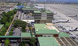
Simón Bolívar International Airport in Maiquetia, Vargas.
Maiquetía is a city in the Vargas state of Venezuela, near Caracas.
Simón Bolívar International Airport, which handles both international and domestic flights, is located in the city. Conviasa, the Venezuelan flag carrier airline, is headquartered in the city.[1]
Maiquetia was badly affected by the 1999 Vargas tragedy.
Climate
| Month | Jan | Feb | Mar | Apr | May | Jun | Jul | Aug | Sep | Oct | Nov | Dec | Year |
|---|---|---|---|---|---|---|---|---|---|---|---|---|---|
| Average high °C (°F) | 28.5 (83.3) |
28.3 (82.9) |
28.5 (83.3) |
29.1 (84.4) |
30.0 (86) |
30.3 (86.5) |
30.1 (86.2) |
30.9 (87.6) |
31.4 (88.5) |
31.3 (88.3) |
30.5 (86.9) |
29.4 (84.9) |
29.86 (85.73) |
| Daily mean °C (°F) | 24.4 (75.9) |
24.5 (76.1) |
24.9 (76.8) |
25.7 (78.3) |
26.6 (79.9) |
26.7 (80.1) |
26.4 (79.5) |
27.0 (80.6) |
27.4 (81.3) |
27.3 (81.1) |
26.7 (80.1) |
25.4 (77.7) |
26.08 (78.95) |
| Average low °C (°F) | 21.9 (71.4) |
21.9 (71.4) |
22.3 (72.1) |
23.3 (73.9) |
24.2 (75.6) |
24.2 (75.6) |
23.8 (74.8) |
24.2 (75.6) |
24.6 (76.3) |
24.6 (76.3) |
24.0 (75.2) |
22.7 (72.9) |
23.48 (74.26) |
| Rainfall mm (inches) | 28.1 (1.106) |
17.1 (0.673) |
22.1 (0.87) |
29.0 (1.142) |
36.1 (1.421) |
53.3 (2.098) |
56.8 (2.236) |
50.3 (1.98) |
54.1 (2.13) |
55.9 (2.201) |
53.6 (2.11) |
54.4 (2.142) |
510.8 (20.109) |
| Avg. rainy days (≥ 1.0 mm) | 3.6 | 2.6 | 1.8 | 2.7 | 4.4 | 6.7 | 7.6 | 7.4 | 7.0 | 6.7 | 5.5 | 5.1 | 61.1 |
| Mean monthly sunshine hours | 232.5 | 220.4 | 241.8 | 183.0 | 201.5 | 207.0 | 241.8 | 244.9 | 228.0 | 207.7 | 195.0 | 210.8 | 2,614.4 |
| Source #1: World Meteorological Organization[2] | |||||||||||||
| Source #2: Hong Kong Observatory[3] | |||||||||||||
References
- ↑ "Contactos." Conviasa. Retrieved on June 14, 2009.
- ↑ "World Weather Information Service - Maiquetía". World Meteorological Information. Retrieved 27 October 2012.
- ↑ "Climatological Information for Maiquetia, Venezuela". Hong Kong Observatory. Retrieved 27 October 2012.
External links
| Wikimedia Commons has media related to Maiquetía. |
This article is issued from Wikipedia. The text is available under the Creative Commons Attribution/Share Alike; additional terms may apply for the media files.