Möhnesee
From Wikipedia, the free encyclopedia
| Möhnesee | ||
|---|---|---|
 | ||
| ||
 Möhnesee | ||
Location of Möhnesee within Soest district 
 | ||
| Coordinates: 51°29′45″N 08°07′50″E / 51.49583°N 8.13056°ECoordinates: 51°29′45″N 08°07′50″E / 51.49583°N 8.13056°E | ||
| Country | Germany | |
| State | North Rhine-Westphalia | |
| Admin. region | Arnsberg | |
| District | Soest | |
| Subdivisions | 18 | |
| Government | ||
| • Mayor | Hans Dicke (Independent_(politician)) | |
| Area | ||
| • Total | 123.38 km2 (47.64 sq mi) | |
| Elevation | 226 m (741 ft) | |
| Population (2012-12-31)[1] | ||
| • Total | 10,916 | |
| • Density | 88/km2 (230/sq mi) | |
| Time zone | CET/CEST (UTC+1/+2) | |
| Postal codes | 59519 | |
| Dialling codes |
02924, 02925 (Brüllingsen, Ellingsen, Völlinghausen) | |
| Vehicle registration | SO | |
| Website | www.moehnesee.de | |

Möhnesee is a municipality in the district of Soest, in North Rhine-Westphalia, Germany.
Geography
The Möhnesee municipality is situated around the Möhne Reservoir (hence the name), approx. 10 km south of Soest.
History
On the night of the 16/17 May 1943, the Dam which contains the Mohnesee was breached in an attack by Avro Lancaster Bombers of 617 Squadron of the British Royal Air Force, the "Dambusters".
In the 1980s the Möhnesee hosted the Campingkirche.
Neighboring municipalities
Notable places
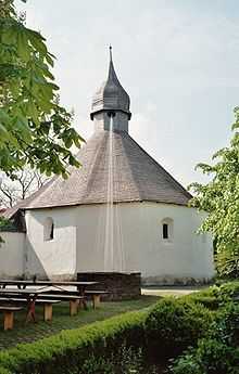
The chapel of Möhnesee-Drüggelte
The Drueggelter Kapelle can be found at Möhnesee-Drüggelte. It is consecrated to the Holy Cross.
Subdivisions
The municipality Möhnesee contains the following 18 subdivisions, with Körbecke as the largest:
|
|
References
- ↑ "Amtliche Bevölkerungszahlen". Landesbetrieb Information und Technik NRW (in German). 31 July 2013.
External links
- Official site (German)
| Wikimedia Commons has media related to Möhnesee. |
| |||||||
This article is issued from Wikipedia. The text is available under the Creative Commons Attribution/Share Alike; additional terms may apply for the media files.