Luynes, Indre-et-Loire
From Wikipedia, the free encyclopedia
| Luynes | |
|---|---|
 | |
 Luynes | |
|
Location within Centre region  Luynes | |
| Coordinates: 47°23′28″N 0°33′19″E / 47.3911°N 0.5552°ECoordinates: 47°23′28″N 0°33′19″E / 47.3911°N 0.5552°E | |
| Country | France |
| Region | Centre |
| Department | Indre-et-Loire |
| Arrondissement | Tours |
| Canton | Luynes |
| Government | |
| • Mayor (2008–2014) | Bertrand Ritouret |
| Area | |
| • Land1 | 34.01 km2 (13.13 sq mi) |
| Population (2009) | |
| • Population2 | 5,025 |
| • Population2 Density | 150/km2 (380/sq mi) |
| INSEE/Postal code | 37139 / 37230 |
| Elevation | 39–105 m (128–344 ft) |
| Website | luynes.fr |
|
1 French Land Register data, which excludes lakes, ponds, glaciers > 1 km² (0.386 sq mi or 247 acres) and river estuaries. 2 Population without double counting: residents of multiple communes (e.g., students and military personnel) only counted once. | |
Luynes is a commune in the Indre-et-Loire department in central France.
Population
| Historical population | ||
|---|---|---|
| Year | Pop. | ±% |
| 1793 | 2,136 | — |
| 1800 | 2,169 | +1.5% |
| 1806 | 2,096 | −3.4% |
| 1821 | 2,004 | −4.4% |
| 1831 | 2,165 | +8.0% |
| 1836 | 2,098 | −3.1% |
| 1841 | 2,003 | −4.5% |
| 1846 | 2,187 | +9.2% |
| 1851 | 2,127 | −2.7% |
| 1856 | 2,109 | −0.8% |
| 1861 | 2,057 | −2.5% |
| 1866 | 2,047 | −0.5% |
| 1872 | 1,981 | −3.2% |
| 1876 | 1,970 | −0.6% |
| 1881 | 1,992 | +1.1% |
| 1886 | 2,014 | +1.1% |
| 1891 | 1,948 | −3.3% |
| 1896 | 1,948 | +0.0% |
| 1901 | 1,846 | −5.2% |
| 1906 | 1,869 | +1.2% |
| 1911 | 1,734 | −7.2% |
| 1921 | 1,530 | −11.8% |
| 1926 | 1,551 | +1.4% |
| 1931 | 1,517 | −2.2% |
| 1936 | 1,533 | +1.1% |
| 1946 | 1,663 | +8.5% |
| 1954 | 1,688 | +1.5% |
| 1962 | 1,699 | +0.7% |
| 1968 | 1,948 | +14.7% |
| 1975 | 2,614 | +34.2% |
| 1982 | 3,834 | +46.7% |
| 1990 | 4,128 | +7.7% |
| 1999 | 4,501 | +9.0% |
| 2006 | 5,002 | +11.1% |
| 2009 | 5,025 | +0.5% |
Sights
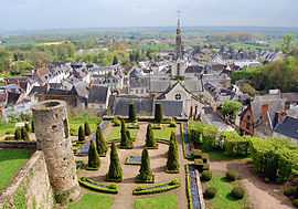
The castle of Luynes has been registered as a historic site since 1926.[1] The construction started in the 13th century, and the building was redesigned in the 15th and 17th century.
See also
References
- ↑ (French) "Château de Luynes in the Base Mérimée database". French Ministry of Culture .
| Wikimedia Commons has media related to Luynes. |
This article is issued from Wikipedia. The text is available under the Creative Commons Attribution/Share Alike; additional terms may apply for the media files.