Luweero District
| Luweero District | |
|---|---|
| District | |
 | |
| Coordinates: 00°50′N 32°30′E / 0.833°N 32.500°E | |
| Country |
|
| Region | Central Uganda |
| Capital | Luweero |
| Population (2010 Estimate) | |
| • Total | 433,100 |
| Time zone | EAT (UTC+3) |
| Website | Homepage |
Luweero District (sometimes spelled Luwero) is a district in Central Uganda. Like many other Ugandan districts, it is named after its main municipal centre, Luweero. The correct phonetic spelling is with two "e"s. However, literature exists where it is spelled with one "e". In fact, the road signs in Uganda spell it with one "e" too.
Location
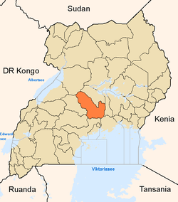
Luweero District is bordered by Nakasongola District to the north, Kayunga District to the east, Mukono District to the southeast, Wakiso District to the south and Nakaseke District to the west.[1] The district headquarters at Luweero are located approximately 75 kilometres (47 mi), by road, north of Kampala, Uganda's capital and largest city.[2] The coordinates of the district are:00 50N, 32 30E (Latitude:0.8333; Longitude:32.500).
Overview
Luweero District was the site of a fierce insurgency by the rebel group National Resistance Army and a brutal counter-insurgency by the government of Milton Obote, known as the Luweero War or the "Bush War", that left many thousands of civilians dead during the early to mid-1980s. The area affected by the war has come to be known as the Luweero Triangle. In 2005, Nakaseke County was split from Luweero District to form Nakaseke District. Luweero District is administered by the Luweero District Administration, with headquarters at Luweero. There are three town councils within the district, each with its own urban town council:
Other towns in the district include:
Population
The 2002 national census estimated the population of the district at about 336,600, with an annual population growth rate of 3.2%.[3] It is estimated that the population of the district in 2010 was about 433,100. See table below:
| Luweero District Population Trends | |||||||||||||||||||||||||||||||||||
Economic activitiesAgriculture is the mainstay of the district economy. It is estimated that 85% of the district population are engaged in agriculture.[4] Agriculture involves both crop and animal husbandry. Livestock is common in the northern areas of Luweero District. Bee keeping for production of honey is an increasing activity in the district. Subsistence agriculture is undertaken in the southern parts of the district. Horticulture for domestic consumption in the cities and for export is also practiced in the southern parts of the district, especially around the towns of Wobulenzi, Bombo and Bamunanika. Crops grown include: LandmarksThe landmarks located in Luweero District include:
External linksSee also
References
| |||||||||||||||||||||||||||||||||||