Lunedale
Coordinates: 54°36′00″N 2°12′32″W / 54.600°N 2.209°W

Lunedale is a dale, or valley, of the east side of the Pennines in England, east of Middleton-in-Teesdale. Its principal villages are Grassholme, Thringarth and West Pasture. Lunedale is part of County Durham.
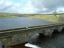
The River Lune flows through Lunedale before reaching Teesdale where it joins the River Tees. The river flows through two reservoirs on the way: Selset Reservoir and Grassholme Reservoir. Running roughly parallel to Lunedale to the south is Baldersdale.
The Pennine Way passes through Lunedale on its way to Middleton-in-Teesdale, and crosses Grassholme Bridge over Grassholme Reservoir.
A former railway viaduct from the now-closed Barnard Castle to Middleton-in-Teesdale line crosses the River Lune just north of Mickleton.
| ||||||||||||||