Luckau
| Luckau | ||
|---|---|---|
| ||
 Luckau | ||
Location of Luckau within Dahme-Spreewald district  | ||
| Coordinates: 51°51′00″N 13°43′00″E / 51.85000°N 13.71667°ECoordinates: 51°51′00″N 13°43′00″E / 51.85000°N 13.71667°E | ||
| Country | Germany | |
| State | Brandenburg | |
| District | Dahme-Spreewald | |
| Government | ||
| • Mayor | Harry Müller (Ind.) | |
| Area | ||
| • Total | 206.38 km2 (79.68 sq mi) | |
| Elevation | 65 m (213 ft) | |
| Population (2012-12-31)[1] | ||
| • Total | 9,738 | |
| • Density | 47/km2 (120/sq mi) | |
| Time zone | CET/CEST (UTC+1/+2) | |
| Postal codes | 15926 | |
| Dialling codes | 03544 | |
| Vehicle registration | LDS | |
| Website | www.luckau.de | |
Luckau (Lower Sorbian: Łuków) is a city in the district of Dahme-Spreewald in the federal state of Brandenburg, Germany. Known for its beauty, it has been dubbed "the Pearl of Lower Lusatia".
Origin of the name
The name appears to be a locative form of a Sorbian root meaning marsh, moor, or wet meadow, in reference to the surrounding countryside.
History

The oldest preserved document mentioning the city of Luckau (using the Slavic form Lukow) dates from the year 1276. A prosperous city, it became one of the capitals of Lower Lusatia in 1492.
By the terms of the Peace of Prague in 1635 during the Thirty Years' War the Margravate of Lower Lusatia was conveyed to the Elector of Saxony, which territory up until that time had been a Bohemian fiefdom.
During the Thirty Years' War the Swedish fortified the city as a principal base. It suffered severe damage as a result of the ensuing conflicts.
On 4 June 1813 during the Napoleonic "War of Liberation", the advance of the French army was halted by the victory of the Russo-Prussian forces of the Sixth Coalition and an armistice was declared in the Truce of Pläswitz. This was briefly interrupted on 6 June by a skirmish at the battle of Luckau.
While conducting an inspection of his troops, Napoleon stayed overnight in Luckau from 20 to 21 July 1813. He requistioned quarters in the top storey of the house belonging to the richest man in the city, a merchant named Vogt. Because it was very cold during that July night, Napoleon had a copper warming pan brought to his bed. This warming pan may still be seen in the Museum of Lower Lusatia in Luckau.
As a result of a decree of the Congress of Vienna in 1815, Lower Lusatia was ceded to Prussia, the Margravate was dissolved, and the region of Lower Lusatia, and thus also the city of Luckau, were annexed to the Province of Brandenburg.
From 1816 to 1993 Luckau held the status of Kreisstadt or "county seat"; it has now been included in the rural district of Dahme-Spreewald, of which the capital is Lübben. Luckau has been a well-known peat-bath spa (Moorbad) since the beginning of the 20th century.
Demography
-

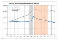
Development of Population since 1875 within the Actual Boundaries (Blue Line: Population; Dotted Line: Comparison to Population Development of Brandenburg state; Grey Background: Time of Nazi rule; Red Background: Time of Communist rule)
-

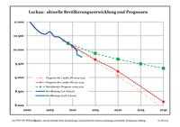
Recent Population Development (Blue Line) and Forecasts
|
|
|
|
Detailed data sources are to be found in the Wikimedia Commons.[3]
Sightseeing

- Lutheran Church of St. Nicholas
The gothic, twin-towered hall church was built during the period from 1375 until 1437. During a fire in the church in 1644 most of the mediaeval furnishings were lost. The restoration of the interior was carried out under the direction of the architects Petzsch and Bärgt in a rich baroque style. The organ, which is exceptionally beautiful, was installed by the Leipzig organ manufacturing company Donath during the years from 1672 to 1674. It presents a richly panelled baroque appearance. Around the year 2002 renovation measures were undertaken at the church.

- Hausmann tower with the Chapel of St. George
The chapel and its grounds, which were built during the 14th century, have been used only for secular purposes since the Reformation.
_-_Roter_Turm.JPG)
- City fortifications
Large portions of the old city wall from the 13th and 14th centuries have been preserved. Particularly remarkable is the Red Tower (Roter Turm).

- Baroque gabled houses
The beautiful marketplace is bordered by numerous baroque dwelling houses. Some of these structures were richly adorned with decorative stucco by Italian baroque master-builders.

- Town hall
The town hall (Rathaus) was built during the 17th century, and later remodeled in neoclassical style.
Transportation
Luckau is located at the nexus of federal motorway (Autobahn) A87 (Torgau-Frankfurt/Oder), A96 (Berlin-Zittau) and A102 (direction of Brandenburg an der Havel by way of Jüterbog).
There is a railway station of the German Railway Corporation ("DB") on the Berlin-Dresden line. The name of the station is "Luckau-Uckro".
Located approximately 10 kilometers to the east of Luckau is exit "Duben" on Autobahn A13. The church of the nearby village of Duben has also been designated as an "Autobahn church."
Districts of the city
- Bergen
- Cahnsdorf
- de:Duben (German)
- Alteno
- Until it was deactivated by the Bundeswehr there was a military airfield with paved runways, a fuel depot and a munitions bunker in Alteno. There were also remotely controlled automatic PAR-8 radio beacons along the main landing approach in the vicinity of Alteno "A" at 1000m and at Groß Radden "AO" at 4000m. During the latter period of the German Democratic Republic it served as an auxiliary and training field for fighter squadron JG-1 in Holzdorf bei Jessen/Elster. The call designation of the field was "Arno". At present the grounds are used for racing by the Luckau motorcycle club.
- Freimfelde
- Kaden
- Egsdorf
- Freesdorf
- Fürstlich Drehna (German)
- Tugam
- Gießmannsdorf
- Görlsdorf
- Frankendorf
- Garrenchen
- Karche-Zaacko – a city quarter with approximately 200 inhabitants in 2006.
- Karche is first documented in 1452 as Karchaw. A Slavic name, it is derived from the personal name Korch. In 1572 it is documented as Karcho.
- Schollen
- Kreblitz
- Kümmritz
- Paserin
- Rüdingsdorf
- Schlabendorf
- Uckro
- Wierigsdorf
- Willmersdorf-Stöbritz
- Terpt
- Zieckau
- Zöllmersdorf
Sister city
- Slawa, Poland (Polish)
References
- ↑ "Bevölkerung im Land Brandenburg nach amtsfreien Gemeinden, Ämtern und Gemeinden 31. Dezember 2012 (XLS-Datei; 83 KB) (Einwohnerzahlen auf Grundlage des Zensus 2011)". Amt für Statistik Berlin-Brandenburg (in German). 31 December 2012.
- ↑ Boundaries as of 2013
- ↑ Population Projection Brandenburg at Wikimedia Commons
External links
- Official website of Luckau (German)
- Church of St. Nicholas in Luckau (German)
- Article about Luckau on sister city's site. (Polish)
- History of the Jews of Luckau (German)
- This article incorporates information from the German Wikipedia.
