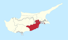
Louroujina Salient
| Luricina Akincilar | |
|---|---|
| Λoυρoυκivα (Greek) Lurucina/Akıncılar (Turkish) | |
 Luricina Akincilar | |
| Coordinates: 35°0′33.34″N 33°27′53.4″E / 35.0092611°N 33.464833°E | |
| Country |
De jure De facto |
| District |
De jure Larnaca District De facto Lefkoşa District |
| Time zone | EET (UTC+2) |
| • Summer (DST) | EEST (UTC+3) |
| Website | http://akincilarbelediyesi.org/ |
The Louroujina Salient (Greek: Λoυρoυκivα, Turkish: Akıncılar, also known as Lurucina) marks the southernmost extent of the Turkish-Cyprus. It is named after the Turkish Cypriot village of Louroujina. Akıncılar was one of the biggest Turkish Cypriot villages in Cyprus before the occupation of the island by Turkey in 1974.
In 1974, this village was secured so as to be placed within a contiguous Turkish Cypriot zone, which later became in 1975, the Turkish Federated State of Cyprus, then in 1983, the self-declared Turkish Republic of Northern Cyprus (TRNC). It is accessible only by one road from the rest of the de facto TRNC. The United Nations Buffer Zone separates the salient from the area controlled by the Republic of Cyprus.
| |||||||||||||||||||
Coordinates: 35°00′33″N 33°27′53″E / 35.00925955°N 33.46483362°E

