Loudon Park Cemetery
 The central portion of the Cemetery | |
| Details | |
|---|---|
| Year established | 1853 |
| Location | Baltimore, Maryland |
| Country | United States |
| Type | Public |
| Owned by | Stewart Enterprises, Inc. |
| Size | 350-acre (142 ha) |
| Website | http://www.loudon-park.com/location/about/cemetery.html |
| Find a Grave | http://www.findagrave.com/cgi-bin/fg.cgi?page=cr&CRid=1973902 |
Loudon Park Cemetery in Baltimore, Maryland is a subsidiary of Stewart Enterprises, Inc., the second largest operator of funeral homes and cemeteries in the United States.[1] The 350-acre (142 ha) cemetery was incorporated in 1853 on the site of the "Loudon" estate, previously owned by James Carey, a local merchant and politician.[2][3] The entrance to the cemetery is located at 3620 Wilkens Avenue.
National Cemetery
A portion of the eastern section is owned by the Federal Government as Loudon Park National Cemetery, acquired in 1861, and holds the remains of 2,300 Union soldiers[2] killed during the Civil War.[3] There is also a Confederate section where about 650 Confederate soldiers are buried,[2] marked by a statue of a Confederate soldier. Since 2003, nearly all of the Confederates in this section have had new markers put on their graves under an "Adopt-a-Confederate" program.[4] The entrance to the National Cemetery portion of Loudon Park is located along Frederick Avenue in the neighborhood of Irvington.
Notable persons
Notable persons interred here include:
- Thomas Beck (December 29, 1909–September 23, 1995), actor
- Charles Joseph Bonaparte (June 9, 1851–June 28, 1921), Former United States Attorney General, former United States Secretary of the Navy, founder of the Federal Bureau of Investigation.
- Jerome Napoleon Bonaparte (July 7, 1805–June 1, 1870), son of Jérôme Bonaparte, nephew of Emperor Napoleon I, father of Charles Joseph Bonaparte.
- William Samuel Booze (January 9, 1862–December 6, 1933, former Congressman from Maryland.
- Abel G. Cadwallader (1841–July 6, 1907), Civil War Medal of Honor recipient.
- Jack L. Chalker (December 17, 1944 – February 11, 2005), author
- Barnes Compton (November 16, 1830–December 2, 1898), former Congressman and Maryland state Treasurer.
- Frederick Nicholls Crouch (July 30, 1808–August 18, 1896), composer
- Charles W. Field (April 6, 1828–April 9, 1892), military officer in the United States, Confederate and Egyptian armies
- John T. Ford (April 16, 1829 – March 14, 1894), operator of Ford's Theater
- James Albert Gary (October 22, 1833–October 31, 1920), former United States Postmaster General.
- Harry Gilmor (January 24, 1838–March 4, 1883), Confederate cavalry officer and Baltimore City Police Commissioner.
- William Kimmel, August 15, 1812–December 28, 1886, U.S. Congressman for Maryland's 3rd District, 1877-1881.
- William W. McIntire, (June 30, 1850–March 30, 1912), U.S. Congressman for Maryland's 3rd District, 1897-1899.
- H. L. Mencken (September 12, 1880–January 29, 1956), journalist, critic, author, and essayist.
- Ottmar Mergenthaler (May 11, 1854–October 28, 1899), inventor of the Linotype.
- Mary Young Pickersgill (1776–1857), Seamstress who made the flag flying over Fort McHenry during the Battle of Baltimore, inspiring Francis Scott Key to write The Star Spangled Banner.[1]
- Robert John Reynolds (March 17, 1838–June 10, 1909), former Governor of Delaware.
The Weiskittel-Roehle Burial Vault, faced with cast iron, was listed on the National Register of Historic Places in 1976.[5]
Images
-

Funeral home and cemetery office, Wilkins Avenue
-

Original main gate and office, Frederick Avenue
-

Firefighters memorial
-
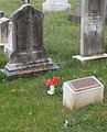
Mary Pickersgill tombstone and plaque
-

NRHP plaque for Weiskittel Mausoleum
-

Weiskittel Mausoleum, made of cast iron to look like masonry
-

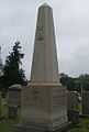
Wiessner Monument, more than three stories high, the tallest monument in the cemetery
-

Harry Gilmor, Confederate officer and Baltimore police commissioner
-

Monument for General Bradley T. Johnson, Confederate States Army
-

Confederate Hill during Confederate Memorial Day, 2012
-

Confederate memorial and graves, Confederate Memorial Day, 2 June 2012
-

One of nearly 600 Confederate soldiers to receive a new marker
-
Bonaparte Monument
-

Abel Cadwallader, Union soldier and Medal of Honor recipient
-

John T. Ford monument
References
- ↑ 1.0 1.1 "Who we are". Loudon Park Cemetery. Retrieved December 6, 2008.
- ↑ 2.0 2.1 2.2 Marsha Wight Wise (2009). Baltimore Neighborhoods. Arcadia Publishing. p. 92. ISBN 978-0-7385-5290-3.
- ↑ 3.0 3.1 "Baltimore Neighborhoods—Irvington". City of Baltimore. Retrieved December 6, 2008.
- ↑ "Adopt a Confederate". Retrieved 12 June 2012.
- ↑ "National Register Information System". National Register of Historic Places. National Park Service. 2008-04-15.
External links
Coordinates: 39°16′54″N 76°40′47″W / 39.28167°N 76.67972°W
| ||||||||||||||||||||||
