Lori Berd
From Wikipedia, the free encyclopedia
| Lori Berd Լոռի բերդ | |
|---|---|
 Lori Berd Լոռի բերդ | |
| Coordinates: 41°0′45.50″N 44°24′45.39″E / 41.0126389°N 44.4126083°ECoordinates: 41°0′45.50″N 44°24′45.39″E / 41.0126389°N 44.4126083°E | |
| Country | Armenia |
| Marz (Province) | Lori Province |
| Elevation | 1,375 m (4,511 ft) |
| Population (2001) | |
| • Total | 450 |
| Time zone | (UTC+4) |
| • Summer (DST) | (UTC+5) |
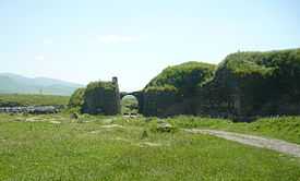
Lori Berd (Armenian: Լոռի բերդ) is a village in the Lori Province of Armenia located just east of Stepanavan. It is the site of the medieval fortress "Lori Berd" located on a peninsula along the deep gorge cut by the Dzoraget and Tashir rivers.
History
Gallery
-
The medieval fortification walls of Lori Berd.
See also
Nearby towns
Nearby villages
References
- '32FA881E6D313774E0440003BA962ED3'&Diacritics=DC Lori Berd at GEOnet Names Server
- Report of the results of the 2001 Armenian Census, National Statistical Service of the Republic of Armenia
This article is issued from Wikipedia. The text is available under the Creative Commons Attribution/Share Alike; additional terms may apply for the media files.


