Longfossé
From Wikipedia, the free encyclopedia
| Longfossé | ||
|---|---|---|
| ||
 Longfossé | ||
|
Location within Nord-Pas-de-Calais region  Longfossé | ||
| Coordinates: 50°39′10″N 1°48′23″E / 50.6528°N 1.8064°ECoordinates: 50°39′10″N 1°48′23″E / 50.6528°N 1.8064°E | ||
| Country | France | |
| Region | Nord-Pas-de-Calais | |
| Department | Pas-de-Calais | |
| Arrondissement | Boulogne-sur-Mer | |
| Canton | Desvres | |
| Intercommunality | Communauté de communes du Pays de la Faïence de Desvres | |
| Government | ||
| • Mayor (2008–2014) | Jean-Claude Pruvost | |
| Area | ||
| • Land1 | 10.22 km2 (3.95 sq mi) | |
| Population (2006) | ||
| • Population2 | 1,275 | |
| • Population2 Density | 120/km2 (320/sq mi) | |
| INSEE/Postal code | 62524 / 62240 | |
| Elevation |
39–207 m (128–679 ft) (avg. 91 m or 299 ft) | |
|
1 French Land Register data, which excludes lakes, ponds, glaciers > 1 km² (0.386 sq mi or 247 acres) and river estuaries. 2 Population without double counting: residents of multiple communes (e.g., students and military personnel) only counted once. | ||

Longfossé is a commune in the Pas-de-Calais department in the Nord-Pas-de-Calais region of France.
Geography
Longfossé is situated some 9 miles (14 km) southeast of Boulogne, at the junction of the D204 and D215 roads..
Population
| 1962 | 1968 | 1975 | 1982 | 1990 | 1999 | 2006 |
|---|---|---|---|---|---|---|
| 1103 | 1151 | 1148 | 1160 | 1218 | 1226 | 1275 |
| Census count starting from 1962: Population without duplicates | ||||||
Places of interest
- The church of St.Pierre, dating from the seventeenth century.
- An eighteenth-century manorhouse.
Gallery
-

Longfossé Town Hall and School
-
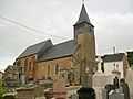
St.Pierre Church
-

A statue of Jesus in the town
See also
References
External links
- Longfossé on the Quid website (French)
This article is issued from Wikipedia. The text is available under the Creative Commons Attribution/Share Alike; additional terms may apply for the media files.