Lok (Titel)
Name
In Serbian, the village is known as Lok (Лок), and in Hungarian as Sajkáslak.| Lok Лок | |
|---|---|
 | |
 Lok | |
| Coordinates: 45°13′N 20°13′E / 45.217°N 20.217°E | |
| Country |
|
| Province |
|
| Municipality | Titel |
| Population (2002) | |
| • Total | 1,255 |
| Time zone | CET (UTC+1) |
| • Summer (DST) | CEST (UTC+2) |

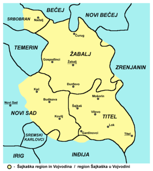
Lok (Serbian Cyrillic: Лок) is a village located in the Titel municipality, in the South Bačka District of Serbia. It is situated in the Autonomous Province of Vojvodina. The village has a Serb ethnic majority and its population numbering 1,255 people (2002 census).
The village Lok live 1024 adult residents, and the average age is 42.4 years (40.5 for men and 44.3 for women). The village has 459 households, and the average number of persons per household is 2.73.
This village is mainly inhabited by Serbs (according to the census of 2002.), And the last three censuses, noticed a decline in population.
In the alluvial plain of the Danube built several sandbars and islands that their relative heights of 5–6 metres dominate the lower and wetter alluvial terrain. In the literature it is considered that these islands and ade neerodirani parts alvijalne terraces created by the Danube with its accumulation. Such a sizeable island was used to build it in a little village named Lok.
To determine the location of the resort is certainly of importance was noted sublime island that is almost always surrounded by swamp and lower alluvial and therefore fairly secure from unwanted passers-by who were travelling along the Danube through the Titel Titel or the Šajkaš and Novi Sad, and Futogu. In the Middle Ages, Novi Sad did not yet exist, then Futog exercised all the functions of a city and economic centre. Just for the record that at the time of fairs Futogu lasted for six weeks.
Population of Lok is on his island, and had a place for the village, as well as pastures and acreage. In this early time was not important to be in a road traffic as the roads are always made in addition to goods and many other major grievances that were sometimes fatal, and for the life of the village and its residents. Lok ties with these Danube through were very poor - by using this swamped and covered with marsh vegetation of the alluvial plain, about 300 metres wide. Over it was not to be drawn carriage or ferry, since carts sank into deep mud, a ferry drew the underwater reefs and willow trees.
When the maximum of water levels on the Danube and the Tisza River alluvial plain had so much water that the only sand island was flooded. This has caused and the Austrian Emperor Joseph II to order the residents of Lok move to the foot of Titel hill beside the Danube times. This relocation of the village residents Lok does not fit, because they hardly come to their countries to the aforementioned sand island. Thus, in 1812. was again relocated to its original location. This displacement is greatly accelerated by order of the military command in Petrovaradin the village mentioned in the road be moved to another location. From old location at the foot of Titel hill remained traces of churches and pubs in Surduk Graz (Gradac). Other sources, however, indicate that in 1825. Lok was not recorded on the county map and that in 1830. a small village with one street of 40 houses and again at the old place, or on a sandy island.
Lok is first mentioned in 1445th in Backa County. Mid-fifteenth century, he was in possession of Titel Archdiocese. Throughout the sixteenth and seventeenth century there is no mention of it, and only the Turkish border Jednaje map out in 1690. The Locke got his tag. Residents of this shop are probably immigrants from the Patriarch of Carnojevic in 1690. Nine years later, Locke already has 27 head of household with 10 married sons. Year in 1715. There are five taxpayers, and 1717th he already paid 30 florins taxes. Two years later, the 1719th Lok has 9, and in 1727. The 11 taxpayers. Year in 1732. population is expected to pay a 54 forint war and 19 florins county taxes.
When it Mošorin and Lok settled praničari demobilized from Subotica, Lok became a military trench. How was designated for Šajkaš, he is following the lifting of the military border was first dosetaka and more years under the county, and then to the šajkaškog Battalion. During the period šajkaškog Locke had significantly more homes. Thus, in 1762. was 32, in 1773. 33, and in 1786. 32 Again, the 1792nd The 39 Serbian homes with 171 inhabitants. After demobilization šajkaškog Battalion 1873 Lok again merged Backa County.
Lok throughout the second half of the nineteenth century and throughout the twentieth century, continuous small village. Census of the 1890s. The Lok has only 1233 inhabitants and 225 houses. According to the mother-tongue population is then divided into: 1 115 Serbs, 73 Hungarians, 34 Germans and Croats 8. According to the Orthodox religion was 1021, 133 Catholics and Evangelicals 22 That same year, the village had loved since 4867 kJ. From this area belonged to the municipality in 1976. The State 897, 211 Đurđevo municipality and private companies in 1783 kJ.
In ethnically Lok and early twentieth century, and in 1981. The extremely Serb.
Lok is mainly the Agricultural village, whose inhabitants referred to the title as well as the economic and administrative center, then Šajkaš and Novi Sad, as well as attractive. There are road and rail link ea this settlement.
For its genesis and development of Lok's favorable conditions and strategic position at the meeting point of two different economic zones, drier and more suitable for dry and damp conditions below are suitable for wet culture.
Road is built 1890s., a railroad in 1899. year.
Source: Bukurov, Branislav "Definitions galaxy monograph of Titel," Academy of Sciences and Arts, Novi Sad, in 1986.
Historical population
- 1961: 1,789
- 1971: 1,688
- 1981: 1,509
- 1991: 1,302
- 2008: 1,402
See also
- List of places in Serbia
- List of cities, towns and villages in Vojvodina
References
- Novi Sad Vojvodina Serbia
| |||||||||||||||||||||||||||||||||||||||||||||||
Coordinates: 45°13′N 20°13′E / 45.217°N 20.217°E
