Logansville, Ohio
From Wikipedia, the free encyclopedia
| Logansville, Ohio | |
|---|---|
| Unincorporated community | |
 | |
 | |
| Coordinates: 40°20′44″N 83°55′50″W / 40.34556°N 83.93056°WCoordinates: 40°20′44″N 83°55′50″W / 40.34556°N 83.93056°W | |
| Country | United States |
| State | Ohio |
| County | Logan |
| Time zone | Eastern (EST) (UTC-5) |
| • Summer (DST) | EDT (UTC-4) |
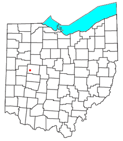
Logansville (also Loganville)[1] is an unincorporated community in central Pleasant Township, Logan County, Ohio, United States. It lies along State Route 47 at its intersection with County Road 24. The Great Miami River flows southward along the western edge of Logansville. The community lies 2 1⁄2 miles (4.0 km) north of the village of De Graff and 9 miles (14½ km) west of the city of Bellefontaine, the county seat of Logan County.[2] It is located at 40°20′44″N 83°55′50″W / 40.34556°N 83.93056°W (40.3456070, -83.9304936), and its altitude is 1,010 feet (310 m).[1]
References
- ↑ 1.0 1.1 U.S. Geological Survey Geographic Names Information System: Logansville, Ohio
- ↑ DeLorme. Ohio Atlas & Gazetteer. 7th ed. Yarmouth: DeLorme, 2004, p. 56. ISBN 0-89933-281-1.
External links
| ||||||||||||||||||||||||||

This article is issued from Wikipedia. The text is available under the Creative Commons Attribution/Share Alike; additional terms may apply for the media files.