Logan Park, Dunedin

.jpg)

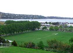
Logan Park is a sporting venue in the city of Dunedin, New Zealand. It lies on land reclaimed from the former Lake Logan.
History
Lake Logan was reclaimed in the early 20th century. Originally an inlet of the Otago Harbour called Pelichet Bay, it frequently silted up, especially after a causeway was built to allow for the South Island Main Trunk Railway between Dunedin and Port Chalmers.
Reclamation began in 1913 and continued after World War I. The reclaimed land was turned into a park and was used as the site of the 1925 New Zealand and South Seas Exhibition. For many years the Dunedin Public Art Gallery stood in one of the buildings constructed for that exhibition. Shortly after the exhibition the reclaimed land was converted into playing fields and now goes by the name of Logan Park. Its location close to the city's two tertiary institutions (Otago Polytechnic, and the University of Otago, especially the Dunedin College of Education) and one of the city's larger high schools (Logan Park High School) makes it an important and heavily used venue.
Features
The park contains soccer and rugby union pitches, an artificial hockey turf, bowling greens, and tennis courts, and part of the park is now occupied by two stadia, the University Oval stadium, home of the University of Otago Rugby Football Club and Otago Cricket, and the Caledonian Ground, which is an athletics venue and also the city's main soccer venue. A new multi-purpose stadium, the Forsyth Barr Stadium at University Plaza, is located close to the southern end of the park. A small creek, the Opoho Creek, flows along Logan Park's eastern perimeter, between the park and Logan Point quarry and the Logan Park High School.
See also
References
| Wikimedia Commons has media related to Logan Park, Dunedin. |
- Herd, J. & Griffiths, G. J. (1980). Discovering Dunedin. Dunedin: John McIndoe.
- History of Dunedin City Council
Coordinates: 45°51′50″S 170°31′30″E / 45.864°S 170.525°E