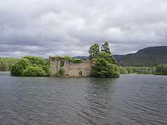
Loch an Eilein
| Loch an Eilein | |
|---|---|
 Loch an Eilein Castle | |
| Location | Badenoch and Strathspey, Scotland |
| Coordinates | 57°08′49″N 3°49′27″W / 57.14694°N 3.82417°WCoordinates: 57°08′49″N 3°49′27″W / 57.14694°N 3.82417°W[1] |
| Type | freshwater loch |
| Primary outflows | Milton Burn |
| Basin countries | United Kingdom |
| Max. length | 0.66 mi (1.06 km)[2] |
| Max. width | 0.5 mi (0.80 km)[2] |
| Surface area | 56.1 ha (139 acres)[1] |
| Average depth | 14.5 ft (4.4 m)[2] |
| Max. depth | 34 ft (10 m)[2] |
| Water volume | 58,000,000 cu ft (1,600,000 m3)[2] |
| Surface elevation | 256 m (840 ft)[1] |
| Islands | 1 island with ruined castle[3] |
Loch an Eilein is a small irregular shaped, freshwater loch in the Rothiemurchus Forest about 5 km (3.1 mi) south of Aviemore, Scotland. Loch an Eilein comes from the Scottish Gaelic and means 'Loch of the island'. The loch is considered to be beautiful[4] and walks around it are popular.[5]
In the late 18th century and early 19th century, the loch was used mainly for two things. On the banks of the loch there is a limestone kiln where the lime stone was collected from a rockface looking over the loch. Also loggers used the connecting river to float logs down to the wood treating factories down stream. Rob Roy and other cattle rustlers used the loch and one side of the loch is called 'Robbers Way'. There are only three remaining houses on the loch side and they are used by forestry officers now.
In the middle of the Loch, on what may be a natural island, are the ruins of a small 15th century castle.[3] The castle is said to have once been the property of Alexander Stewart the Wolf of Badenoch.[6] The Jacobites, retreating from Cromdale in 1690, besieged the castle, which was held by Dame Grizel Mor Grant, widow of the fifth laird Grant. At this time the castle was connected to the shore by a causeway. The causeway was lost when the water level in the loch was raised in the 18th century.
The loch was surveyed[2] on 9 August 1902 by James Murray and later charted[7] as part of The Bathymetrical Survey of Fresh-Water Lochs of Scotland 1897-1909 .[8]
The loch and the forest around it are popular with birdwatchers, walkers, mountain bikers and day-trippers. Among the birds found on or around Loch an Eilein are Crested Tit, Redstart, Spotted Flycatcher, Tree Pipit, Red-throated Diver, Common Sandpiper, Whinchat, and the occasional Merlin.
References
- ↑ 1.0 1.1 1.2 "Loch an Eilein". http://www.britishlakes.info/. Retrieved 2013-11-17.
- ↑ 2.0 2.1 2.2 2.3 2.4 2.5 "Bathymetrical Survey of the Fresh-Water Lochs of Scotland, 1897-1909, Lochs of Orkney". http://www.nls.uk/. Retrieved 2013-11-17.
- ↑ 3.0 3.1 "Loch-an-eilein Castle". http://www.scotlandsplaces.gov.uk/. Retrieved 2013-11-17.
- ↑ "Loch-an-eilein voted Britain's best picnic spot". http://www.rothiemurchus.net/=. Retrieved 2013-11-17.
- ↑ "Loch an Eilein, Rothiemurchus". hhttp://www.walkhighlands.co.uk/=. Retrieved 2013-11-17.
- ↑ [hhttp://www.scottish-places.info/scotgaz/features/featurefirst2377.html "Eilein, Loch an"]. http://www.scottish-places.info/. Retrieved 2013-11-17.
- ↑ "Loch an Eilein; Loch Bad a' Chrotha; Loch Braigh Horrisdale; Loch Bad an Sgalaig and Dubh Loch (Vol. 5, Plate 18) ) - Bathymetrical Survey, 1897-1909 - National Library of Scotland". maps.nls.uk. Retrieved 2013-11-17.
- ↑ Murray, John; Pullar, Laurence (1910). Bathymetrical Survey of Fresh-Water Lochs of Scotland during the years 1897 to 1909: report on scientific results. Edinburgh. Retrieved 2013-11-17.
External links
- Engraving of Loch-an-Eilan by James Fittler in the digitised copy of Scotia Depicta, or the antiquities, castles, public buildings, noblemen and gentlemen's seats, cities, towns and picturesque scenery of Scotland, 1804 at National Library of Scotland