Llanwrin
From Wikipedia, the free encyclopedia
Coordinates: 52°36′57″N 3°47′33″W / 52.6157°N 3.7925°W
| Llanwrin | |
 Llanwrin in 2006 |
|
 Llanwrin | |
| OS grid reference | SH787034 |
|---|---|
| Principal area | Powys |
| Ceremonial county | Powys |
| Country | Wales |
| Sovereign state | United Kingdom |
| Post town | MACHYNLLETH |
| Postcode district | SY20 |
| Dialling code | 01650 |
| Police | Dyfed-Powys |
| Fire | Mid and West Wales |
| Ambulance | Welsh |
| EU Parliament | Wales |
| UK Parliament | Montgomeryshire |
Llanwrin (![]() pronunciation (help·info)) is a small village in the valley of the Afon Dyfi in Powys about two miles north-east of Machynlleth.
pronunciation (help·info)) is a small village in the valley of the Afon Dyfi in Powys about two miles north-east of Machynlleth.
History and background
Historically, it was in the county of Montgomeryshire (Welsh: Sir Drefaldwyn).
The village is named after its church, dedicated to St. Gwrin, which dates from late medieval times and was last restored in 1864. [1]
Once a thriving community with its own Blacksmiths, Public House and village shop, all long since closed, in recent years the village has been a collection of houses stretched along the B4404 road.
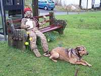
Straw man
Llanwrin is known locally, for its various Straw man characters which are located from time to time on the small triangle shaped village green.
The Strawman
References
External links
- Photos of Llanwrin and surrounding area on geograph
- Eco Dyfi Valley Partnership
- Genealogical information about Llanwrin
- Map of Llanwrin in 1837

This article is issued from Wikipedia. The text is available under the Creative Commons Attribution/Share Alike; additional terms may apply for the media files.