Lizard Head
| Lizard Head | |
|---|---|
 | |
| Elevation | 13,119 ft (3,999 m)[1] |
| Prominence | 1,134 ft (346 m)[1] |
| Location | |
| Location | Dolores / San Miguel counties, Colorado, U.S. |
| Range | San Juan Mountains |
| Coordinates | 37°50′09″N 107°57′02″W / 37.8358276°N 107.9506236°WCoordinates: 37°50′09″N 107°57′02″W / 37.8358276°N 107.9506236°W[2] |
| Topo map | USGS Mount Wilson |
| Geology | |
| Type | Ash flow tuff[3] |
| Age of rock | Oligocene |
| Climbing | |
| First ascent | 1920 by Albert Ellingwood and Barton Hoag |
| Easiest route | Technical climb; class 5.8 |

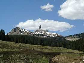
Lizard Head (often called Lizard Head Peak) is a mountain in Colorado, one of the 637 peaks above 13,000 feet in elevation in the state (see thirteeners). It is located in the San Juan Mountains on the border between San Miguel County and Dolores County, within the Lizard Head Wilderness and just southeast of a group of three Colorado fourteeners, Mount Wilson, Wilson Peak, and El Diente Peak. Lizard Head is only the 556th highest peak in Colorado by most standard definitions,[4] but its towering spire-like form makes it one of the most spectacular.
Lizard Head lies 2.84 mi (4.57 km) northwest of Colorado State Highway 145 at Lizard Head Pass. Lizards Head Trail climbs west from Trout Lake along Black Face Mountain ridge and past the south face of Lizard Head toward Wilson Peak.[5]
The peak was used in a famous logo by the Rio Grande Southern Railroad.
Geology
The rock spire of Lizard Head looks like an old eroded volcanic plug but it is actually composed of extrusive volcanic ash flows of Oligocene age resting on older sedimentary rocks of Eocene age.[3]
Climbing
Lizard Head is one of the most difficult summits in Colorado to climb.[6] The story of the first ascent makes a memorable and harrowing tale. In the words of Albert Ellingwood,
A rottener mass of rock is inconceivable. The core may still be solid but the "surrounding tuffs" are seeking a lower level in large quantities. This far-advanced disintegration was our greatest obstacle. Absolutely the whole surface of the rock is loose and pebbles rain down from the sides as readily as needles from an aging Christmas tree. In many places one could with one hand pull down hundreds of pounds of fragments, and occasionally we could hear the crashing of small avalanches that fell without human prompting.[7]
Despite the serious and daunting objective hazards, the first ascent team completed the climb and descent safely in a feat of mountaineering skill.
References
- ↑ 1.0 1.1 "Lizard Head, Colorado". Peakbagger.com. Retrieved 2013-05-31.
- ↑ "Lizard Head". Geographic Names Information System, U.S. Geological Survey. Retrieved 2009-01-20.
- ↑ 3.0 3.1 Blair, Ron, Geology of the Western San Juan Mountains and a Tour of the San Juan Skyway, Southwestern Colorado in Blair, Ron (editor), (1996) The Western San Juan Mountains: their geology, ecology and human history, University Press of Colorado. Retrieved 2013-07-12.
- ↑ "Colorado’s Summits – 13,000 to 13,999 feet". Climb.Mountains.com. Retrieved 2007-03-04.
- ↑ Mount Wilson, Colorado, 7.5 Minute Topographic Quadrangle, USGS, 1953
- ↑ Jacobs, Randy, ed.; with Robert M. Ormes (2000). Guide to the Colorado Mountains (10th ed.). Colorado Mountain Club. ISBN 0-9671466-0-7.
- ↑ Ellingwood, Albert L. (1921). "First to Climb Lizard Head". Outing. LXXIX (2).
External links
- "Lizard Head Peak". 13ers.com. Retrieved 2007-03-04.
- Bell, George. "Lizard Head (2001 climb)". Retrieved 2007-03-04.
| Wikimedia Commons has media related to Lizard Head Wilderness. |