Lhünzhub County
| Lhünzhub County | |
|---|---|
| County | |
| Tibetan transcription(s) | |
| • Tibetan | ལྷུན་གྲུབ་རྫོང་ |
| • Wylie transliteration | lhun grub rdzong |
| Chinese transcription(s) | |
| • Simplified | 林周县 |
| • Pinyin | Línzhōu Xiàn |
 | |
.png) | |
 Lhünzhub County | |
| Coordinates: 30°21′25″N 91°28′30″E / 30.35694°N 91.47500°E | |
| Country | China |
| Province | Tibet |
| Prefecture | Lhasa Prefecture |
| Capital | Lhünzhub |
| Area | |
| • Total | 4,512 km2 (1,742 sq mi) |
| Population (1999) | |
| • Total | 50,895 |
| Time zone | China Standard (UTC+8) |
Lhünzhub or Linzhou (Standard Tibetan: ལྷུན་གྲུབ་རྫོང་; Wylie: lhun grub rdzong; simplified Chinese: 林周县; pinyin: Línzhōu Xiàn) is a county towards the north-east of the main centre of Lhasa, Tibet.
It has a population of 50,895 people as of 2000.[1]
Geography and climate
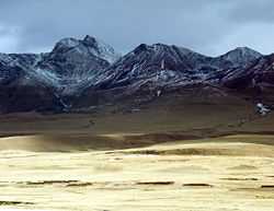
Lhünzhub County is located in central Tibet in the Peng Po Valley, around 65 km northeast of Lhasa. It covered an area of 4512 square kilometers in 2003 and the county was established in 1857.[1] The county was reorganized to cover more territory in 1959. The Nyainqentanglha Mountains passes through the county across the central Tibetan plateau, and eventually spread for about 600 km from west to east, beyond even the Lhasa Prefecture.[1]
Lhünzhub has a cool dry climate with an annual temperature ranging on average between 2.9 and 5.8 degrees celsius, and the main river is the Lhasa River flowing through the Peng Po Valley, with an average elevation of 3860 meters.[1] Natural disasters such as floods, landslides, drought, hail, avalanches etc. are common.
As of 2000, Lhünzhub County has jurisdiction over one town (Lhünzhub)and 9 townships.[1]
Settlements
- Chunduixiang
- Gana
- Kazixiang
- Lhünzhub
- Mainacun
- Seronggang
- Tiangacun
- Zhujiecun
Economy
Lhünzhub County is a large agricultural county, with some 18 million mu of cultivated land, accounting for one third of the cultivated area of the Lhasa Prefecture. It has all kinds of livestock particularly yak, sheep, goats and horses.
In 2004 the county earned 350 million yuan of gross domestic product, with 2649 yuan per capita per farmer.[1] In 2007, the economy had grown by 17%, with a GDP of 562 million yuan. 190.672 million yuan was invested in Lhünzhub county in 2003 in capital construction projects.
The main crops are highland barley, winter wheat, spring wheat, rapeseed and vegetables, with a total output of 120 million kilograms of grain.[1] The main mineral resources are lead, zinc, barite, coal, gypsum, etc. and the main wildlife includes deer, black-necked cranes, chickens, gray duck, pheasant, Mongolian gazelle etc.
There are two hydropower stations in Lhünzhub County and Hutoushan Reservoir is located towards the south. The ceramics industry has a long history and many people are employed in the crafs making pots etc.[1] There are also speciality arts and crafts exhibitions.
The county has three major highways, and Highway 12 has a total length of more than 260 km. In 2003, the county had 55 medical institutions including a hospital with 70 beds.[1]
Religion
A religious county, it has a total of 37 temples, and some 1055 monks and nuns in 2003 mainly following Tibetan Buddhism.[1]
Reting Monastery is located in Lhünzhub County and was built in 1056 by Dromtönpa (1005–1064) and was the seat of the Kadampa school of Buddhism. In 1240 the Mongols raided the monastery severely and in 1397, Tsongkhapa had a vision of Atisha (Kadampa's founder) and reformed the Kadampa school into the Gelugpa sect. The cultural revolution left it severely damaged but in recent years a lot of reconstruction work was done. About 160 monks reside in Reting.
References
| ||||||||||||||||||||||||||||||||||||
| |||||||||||||||||||||||||||


Coordinates: 30°21′25″N 91°28′30″E / 30.35694°N 91.47500°E