Leslie Harrison Dam
From Wikipedia, the free encyclopedia
| Leslie Harrison Dam | |
|---|---|
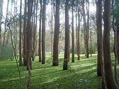
 Trees bordering dam while its at 100% capacity, 2011 | |
| Location | 16km SE of Brisbane |
| Coordinates | 27°31′50″S 153°10′44″E / 27.5306°S 153.179°ECoordinates: 27°31′50″S 153°10′44″E / 27.5306°S 153.179°E |
| Type | reservoir |
| Catchment area | Tingalpa Creek |
| Basin countries | Australia |
| Water volume | 24,800 ML [1] |
| References | [1] |
The Leslie Harrison Dam is a water storage reservoir for the Redland City Council. The dam forms Tingalpa Reservoir which is situated between the suburbs of Capalaba, Chandler and Burbank in Brisbane, Australia.
The dam was completed in 1968 and provides approximately 20% of Redland Shire town water supply. When full, excess water flows over the spillway into the lower reaches of Tingalpa Creek.
In July 2008, the Government of Queensland took over ownership of the dam as part of a water security project in the South East Queensland region, known as the South East Queensland Water Grid.[2]
Swimming is prohibited, but the state government plans to allow fishing and recreational use of the reservoir in late 2013.[3]
See also
References
- ↑ 1.0 1.1 Seqwater rainfall and dam level update
- ↑ Daniel Hurst (2009-07-07). "Water funds slash debt". The Bayside Bulletin. Fairfax Digital. Retrieved 2008-04-21.
- ↑ Judith Kerr (2013-03-14). "Leslie Harrison Dam to open for recreational use". Bayside Bulletin. Fairfax Digital. Retrieved 2013-05-18.
This article is issued from Wikipedia. The text is available under the Creative Commons Attribution/Share Alike; additional terms may apply for the media files.