Lehigh Canal
|
Lehigh Canal | |
 | |
|
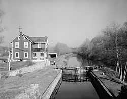
The Lehigh Canal as seen from Guard Lock 8 & Lockhouse, Island Park Road, Glendon, Northampton County, PA | |
 Lower division of the Lehigh Canal, from Jim Thorpe, PA to Easton, PA | |
| Location | Lehigh River |
|---|---|
| Coordinates | 40°46′09″N 75°36′13″W / 40.76917°N 75.60361°WCoordinates: 40°46′09″N 75°36′13″W / 40.76917°N 75.60361°W |
| Built | 1819 |
| Architect | Canvass White, Josiah White |
| Governing body | Local |
| NRHP Reference # | 78002437, 78002439, 79002179, 79002307, 80003553[1] |
| Added to NRHP | Earliest October 2, 1978 |
The Lehigh Canal was constructed by the Lehigh Coal & Navigation Company to carry anthracite from the upper Lehigh Valley to the urban markets of the northeast, especially Philadelphia. With the discovery of large deposits of anthracite coal, the Lehigh Coal Mine Company was formed to transport the coal down the Lehigh River to the Delaware River and on to the growing consumer markets in Philadelphia via a connection with the Pennsylvania Canal (Delaware Division) in Easton.
History
The Lehigh Canal, designed by Canvass White, an engineer of New York's Erie Canal, was constructed between 1827 and 1829. The enlarged Lehigh Navigation extended 46 miles (74 km) between Mauch Chunk, Pennsylvania (present-day Jim Thorpe) and Easton with 52 locks, eight guard locks, eight dams and six aqueducts, allowing the waterway to overcome a difference in elevation of over 350 feet (107 m). A weigh lock determined canal boat fees a half mile (1 km) south of Mauch Chunk. A connection across the Delaware River to the Morris Canal through New Jersey allowed the coal from the Lehigh Canal to be shipped more directly to New York City.
During the 1830s, an extension of 26 miles (42 km) to White Haven, Pennsylvania, which included 20 dams and 29 locks, was constructed, covering a difference in elevation of over 600 feet (183 m) to Mauch Chunk.
In 1855, the canal reached its peak of more than one million tons of cargo. However, competition from railroads and the catastrophic flood of June 4, 1862, were all steps towards the canal's demise. The canal was used as a means of transportation until the 1940s (about a decade after other similar canals ceased operations), making it the last fully functioning towpath canal in North America. In 1962, most of it was sold to private and public organizations for recreational use.
Historic registry
Several segments of the canal were listed on the National Register of Historic Places in 1979, under listing names "Lehigh Canal", "Carbon County Section of the Lehigh Canal" (#79002179), "Lehigh Canal: Eastern Section Glendon and Abbott Street Industrial Sites" (#78002437), "Lehigh Canal; Allentown to Hopeville Section" (#79002307) and others.
For the Carbon County section, also known as "Upper Canal Lock #1 to Lower Canal Dam #3", the listing included 30 contributing structures.[1]
The Eastern section runs along the Lehigh River from Hopeville to the confluence of the Lehigh and Delaware Rivers in Easton, Pennsylvania and includes the Chain Bridge, which was separately NRHP-listed in 1974. The Eastern section listing is for a 260-acre (110 ha) area with three contributing buildings, seven contributing sites, and 11 contributing structures.[1]
The Allentown to Hopeville section is a 53.9-acre (21.8 ha) area that includes Greek Revival and vernacular Federal architecture among its one contributing building and 13 contributing structures.[1]
Current usage
An 8-mile (13 km) segment of the canal towpath has been converted into a multi-use trail that runs from Freemansburg through Bethlehem to Allentown. The trail runs along the river and active railroad tracks. A section near Jim Thorpe is accessible to recreational users. The final section in Easton is maintained and operated by the National Canal Museum. Other short sections are accessible, but there are parts of the canal towpath that have been worn by the elements and are not safe to access.[2]
Pictures
-

Loading coal at the Mauch Chunk chutes, 1873
-

Weigh lock with scales to determine tolls, 1873
-
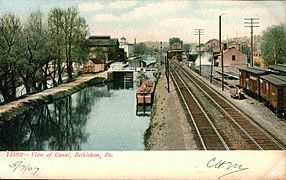
The canal passing through Bethlehem, 1907
-

Remains of Lock 25, 2006
-

Image of Gate entrance of Lock 28
-

Stacked rock detail of lock wall of Lock 28 near White Haven, 2008
See also
- Delaware and Lehigh National Heritage Corridor
- Pennsylvania Canal (Delaware Division) – a sister canal along the Delaware River that provided a connection to the Philadelphia markets via a link up in Easton
- Morris Canal – a New Jersey canal that provided direct access to the New York City markets via a cross-Delaware River connection in Phillipsburg, New Jersey
- List of canals in the United States
References
- ↑ 1.0 1.1 1.2 1.3 "National Register Information System". National Register of Historic Places. National Park Service. 2009-03-13.
- ↑ "Lehigh Canal". National Canal Museum. Retrieved November 23, 2013.
External links
| Wikimedia Commons has media related to Lehigh Canal. |
- Historic American Engineering Record (HAER) No. PA-133, "Lehigh Canal, Easton Dam"
- Historic American Engineering Record (HAER) No. PA-136, "Lehigh Canal, Outlet Lock"
- Historic American Engineering Record (HAER) No. PA-139, "Lehigh Canal, Guard Lock 8 & Lockhouse"
- Historic American Engineering Record (HAER) No. PA-140, "Lehigh Canal, Lock 44"
- Historic American Engineering Record (HAER) No. PA-149, "Lehigh Canal, Lock 40"
- Historic American Engineering Record (HAER) No. PA-153, "Lehigh Canal, Hokendauqua Dam"
- Historic American Engineering Record (HAER) No. PA-158, "Lehigh Canal, Guard Lock 5"
- Historic American Engineering Record (HAER) No. PA-160, "Lehigh Canal, Lock 25"
- Historic American Engineering Record (HAER) No. PA-162, "Lehigh Canal, Lock 20"
- Historic American Engineering Record (HAER) No. PA-165, "Lehigh Canal, Lock 10"
- Historic American Engineering Record (HAER) No. PA-171, "Lehigh Canal, Slate Dam"
- Historic American Engineering Record (HAER) No. PA-176, "Lehigh Canal, Freemansburg"
- National Canal Museum: Lehigh Navigation
- Historic photos of the Lehigh Coal and Navigation Canal
- Delaware & Lehigh Canal State Heritage Corridor
- Lehigh Canal History
| ||||||||||||||||||||||||||||||||||||||
| ||||||||||||||||||||

