Lechmere Viaduct
From Wikipedia, the free encyclopedia
| Charles River Viaduct | |
|---|---|
 The Lechmere Viaduct as viewed from East Cambridge | |
| Carries | Light rail |
| Crosses | Charles River |
| Locale | Boston, Massachusetts to Cambridge, Massachusetts |
| Design | Arch bridge[1] |
| Opened | 1910[1] |
| Coordinates | 42°22′05″N 71°04′13″W / 42.36803°N 71.07035°WCoordinates: 42°22′05″N 71°04′13″W / 42.36803°N 71.07035°W |
 | |
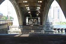
Lechmere Viaduct, looking west beneath the Science Park/West End MBTA station
The Lechmere Viaduct is the last remaining elevated portion of the MBTA's Green Line in Boston, Massachusetts. Opened June 1, 1912, the Viaduct connects the Lechmere stop (the northern terminus of the line) to the Science Park Station at Leverett Circle. Currently, the Green Line descends into a tunnel just east of Science Park station.
Until 2004, the viaduct connected to the Causeway Street Elevated. When the new North Station "superstation" was fully opened in 2005, a new incline next to Martha Road was built to connect the new tunnel to the existing viaduct.
References
See also
External links
![]() Media related to Lechmere Viaduct at Wikimedia Commons
Media related to Lechmere Viaduct at Wikimedia Commons
| ||||||||
| ||||||||||||||||||||||
| |||||||||||||||||||||||||||||||||||||||||||||||||||||||||||||||||||||||||||||
This article is issued from Wikipedia. The text is available under the Creative Commons Attribution/Share Alike; additional terms may apply for the media files.