Leagrave
| Leagrave | |
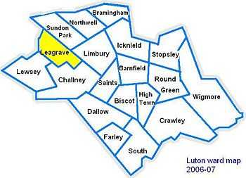
 Leagrave | |
| Population | 12,910 [1] |
|---|---|
| OS grid reference | TL0523 |
| Unitary authority | Luton |
| Ceremonial county | Bedfordshire |
| Region | East |
| Country | England |
| Sovereign state | United Kingdom |
| Post town | LUTON |
| Postcode district | LU3, LU4 |
| Dialling code | 01582 |
| Police | Bedfordshire |
| Fire | Bedfordshire and Luton |
| Ambulance | East of England |
| EU Parliament | East of England |
| UK Parliament | Luton North |
| |
For other uses see Leagrave
Leagrave is a former village and now a suburb of Luton in Bedfordshire in the northwest of the town. Connected by train from Leagrave station into London and Bedford by First Capital Connect. The M1 is close at hand as well as Luton Airport.
History
The first settlement in the area was Waulud's Bank which is a Neolithic D-shaped enclosure in Leagrave Park at the source of the River Lea and is now a protected monument. Waulud's bank consists of a bank and external ditch of around 7 hectares with a turf reveted chalk and gravel bank (built from the excavated ditch material). The ditch itself is about 9 m wide and 2 m deep. Finds at the site have included neolithic Grooved Ware and flint arrow heads. It is a similar site to Durrington Walls and Marden and the site was later re-used in the Iron Age and during the Roman occupation.
The Icknield Way, a pre Roman road, passes though Leagrave. Local road names give away its location, 'Roman Road' runs from Oakley Road to Marsh Road. On the other side of Marsh Road as the road enters Limbury it continues as 'Icknield Road' where there is a gap before the road continues as Icknield Way.


The River Lea/(Lee) starts in Leagrave before making its way eventually to the Thames, joining in London. The Lee crosses Leagrave Common and receives a tributary called Knapps Brook which joins from culverts under the railway embankment and Toddington Road. Napps Brook is a combination of brooks from East End, Houghton Regis and from the Lewsey Estate near the old Lewsey Farm. The river once formed one boundary of the Danelaw. Leagrave Marsh used to be a popular place for the Luton hatters on their (rare) days off and was, consequently, known as "Blockers' Seaside". The hatmaking industry originally relied on straw plaits, made by farmers' wives, bought and collected by a "plaitman" and brought into the Luton hat factories to be made into straw hats. A new artwork has been unveiled in the area, reflecting on this former use of the area.[2]
The manor of Leagrave was held by the Lucy family from 1305 to 1455. The Lucys gave their name to the area of Luton known as Lewsey.[3]
Leagrave station was built by the Midland Railway company in 1868 on its extension to St Pancras. The old Midland station buildings still exist, having been carefully restored in the 1980s.
In 1866 the villages of Leagrave and Limbury were formed into the ecclesiastical parish of 'Holy Trinity, (Biscot)'.[4] Thirty years later, in 1896 Leagrave civil parish was formed under the provisions of the 'Local Government Act 1894', in the ecclesiastical parish of Limbury-cum-Biscot.
In 1914 Hewlett & Blondeau Limited, an aircraft manufacturing business, opened a factory at Leagrave called The Omnia Works.[5] The company was managed by Hilda Hewlett who lived on site. During the First World War the factory produced more than 800 aircraft and employed up to 700 people. The business closed in 1920 and in 1926 the factory site was sold to Electrolux.
The area grew significantly in between the wars and in 1928 the parish was abolished when the boundaries of Luton were extended to include Leagrave, as well as Limbury and Stopsley. Further expansion of the area took place during the 1930s; much of the housing stock of the area dates from the 1920s and 1930s. Further large scale construction continued post-war with the construction of the Hockwell Ring estate and nearby Marsh farm. Some of the old farm names live on in the modern road names, Strangers Farm lends its name to the current Strangers Way, Grange Avenue (Grange Road until the 1920s) takes its name from The Grange Farm, and at the edge of Leagrave Marsh was Marsh Farm, which gives its name to the 1960s estate, Marsh Farm.
Until recently Electrolux was one of the larger employers in the area, however much of the old factory site was sold off over the last ten years or so for re-development into housing. The most recent development on the site was Saxon-Gate. Leagrave is increasingly a commuter area with many people taking advantage of the train and motorway connections into London and to the North. There have been many smaller developments of former industrial land creating many new apartment blocks and also infil housing.
The current site of the McDonald's restaurant on Marsh Road was the site of the Three Horseshoes pub, which was demolished in 1994.[6] The roundabout next to McDonalds takes its name from the old pub, and the old pub sign can still be seen in the planting scheme.
Following Leagrave becoming part of Luton in 1928, many local roads were renamed to avoid confusion with existing Luton road names. For example Oak Road became Oakley Road, Cumberland Avenue became Compton Avenue and Salisbury Road became Sarum Road (Sarum being the Roman name for Salisbury).
Etymology
The village was recorded in 1224 as Littegraue, intimating that its name means 'Light-coloured, or lightly wooded, grove'.[7] However, another source suggests its name originates from Lygegrove: "Lyge" being an old name for the River Lea.[8]
Sport and leisure
Leagrave has a Non-League football team Kent Athletic F.C. who play at Kent Athletic Park.
Future Transport Plans
New Bridge Under the Mainline Railway
The Bedford to London railway line cuts a portion of Luton off from the rest of it, this scheme will add a new crossing under the track near Leagrave park. This scheme is a reserve scheme and as such may only be developed should one of the 79 chosen schemes not be able to be completed.
Local Schools and education
- Kings House Preparatory School & Nursery, High Street Leagrave
- Leagrave Primary School, Strangers Way
- Beechwood Primary School, Linden Road
- Barnfield Moorlands Free School, Leagrave Hall
- Lealands High School, Sundon Park Road
- Leagrave Library, Marsh Road
Moorlands School and Nursery was founded in 1891. It was originally located in the town centre before moving to Dunstable Road. In 1958 the school had grown significantly and new premises were needed. The school relocted to Leagrave Hall (built in 1850), a former home of the Filmer family.[9][10] In September 2011, Barnfield Moorlands Free School became a free school, the first such school in Luton and all of Bedfordshire, when it joined the Barnfield Federation in September 2012.[11]
Churches

The largest church in the parish is St Lukes on Leagrave High Street, which was consecrated by the Bishop of Saint Albans in June 1956.[12] It is a grade II listed building[13][14] due largely to its frontage,[15] and was designed by John Seely and Paul Paget.
Leagrave Methodist Church is also on Leagrave High Street. The first Methodist Church in Leagrave opened on 3 June 1824, and a gallery was added 5 years later in 1829. This Church was rebuilt in 1880.[16]
Politics
See also Politics in Luton
Leagrave ward is represented by Cllr Waheed Akbar(Labour), Cllr Sheila Roden (Labour) and Cllr Desline Stewart (Labour).[17]
The ward forms part of the parliamentary constituency of Luton North, and the MP is Kelvin Hopkins (Labour). Leagrave is within the East of England.
Local Attractions
| Key | |
| | Abbey/Priory/Cathedral |
| | Accessible open space |
| | Amusement/Theme Park |
| | Castle |
| | Country Park |
| | English Heritage |
| | Forestry Commission |
| | Heritage railway |
| | Historic House |
| | Museum (free/not free) |
| | National Trust |
| | Theatre |
| | Zoo |
|
Local Newspapers
Two weekly newspapers are delivered free to all houses in Leagrave, with news about Leagrave and the surrounding area.
- Herald and Post (Luton based) – Delivered every Thursday
- Luton on Sunday – Delivered every Sunday
References
- ↑ Luton Borough Council, Population Estimates and Forecasts, estimate for Leagrave ward in 2007.
- ↑ Opening of artwork at the Blockers Seaside
- ↑ Davis, Frederick (1855). The History of Luton. p. 39.
- ↑ Leagrave parish history
- ↑ History of Hewlett & Blondeau
- ↑ Details about demolition of the Three Horseshoes Pub
- ↑ Mills, A.D. (1991). The Popular Dictionary of English Place-Names. Oxford: Phaidon. "Leagrave Beds. Littegrave 1224. 'Light-coloured, or lightly wooded, grove'. OE lēoht + grāf."
- ↑ Davis, Frederick (1855). The History of Luton.
- ↑ http://www.galaxy.bedfordshire.gov.uk/webingres/bedfordshire/vlib/0.digitised_resources/leagrave_timeline.htm Bedfordshire Library Leagrave Timeline
- ↑ http://www.moorlands.barnfield.ac.uk Barnfield Moorlands Free School website
- ↑ http://www.luton-dunstable.co.uk/News/Moorlands-among-Free-School-pioneers-05092011.htm
- ↑ http://www.stlukesleagrave.org/History.html
- ↑ http://www.lutonheritageforum.org/site_record_0048.html
- ↑ http://www.luton.gov.uk/Environment/Land_and_premises/Buildings/Pages/Statutory%20register%20listed%20buildings.aspx
- ↑ http://www.eplan.luton.gov.uk/plannet/documentstore/DC19512563-32-1_AF_A.PDF
- ↑ http://virtual-library.culturalservices.net/webingres/bedfordshire/vlib/0.digitised_resources/leagrave_timeline.htm
- ↑ http://www.luton.gov.uk/internet/references/popular%20topics/elections/local_elections/local%20election%20results/leagrave%20ward
External links
| Wikimedia Commons has media related to Leagrave. |
- Luton Borough Council
- Leagrave Library
- Kelvin Hopkins homepage
- St Lukes Church
- Views of Leagrave and Limbury from 1906
| |||||
| |||||||||||||||||