Lawson Heights, Saskatoon
| Lawson Heights | |
|---|---|
| Neighborhood | |
 | |
| Coordinates: 52°10′16″N 106°37′10″W / 52.17111°N 106.61944°WCoordinates: 52°10′16″N 106°37′10″W / 52.17111°N 106.61944°W | |
| Country |
|
| Province |
|
| City | Saskatoon |
| Suburban Development Area | Lawson Suburban Development Area |
| Neighbourhood | Lawson Heights |
| Government | |
| • Type | Municipal (Ward 5) |
| • Administrative body | Saskatoon City Council |
| • Councillor | Randy Donauer |
| Area | |
| • Total | 1.485 km2 (0.573 sq mi) |
| Population (2006) | |
| • Total | 4,815 |
| • Density | 3,200/km2 (8,400/sq mi) |
| • Average Income | $78,130 |
| Time zone | CST (UTC-6) |
Lawson Heights derived its origins when Reverend Stephen George Lawson homesteaded here on the North east quarter of section 10 Township 37 Range 5 West of the 3rd Meridian. He had come from Prince Edward Island and was a Presbyterian minister.[1][2]
Lawson Heights is a community which has come together mainly in the 1970s tapering off in the 1980s when the community became established. The average family size is 2.7 with homeownership at 64.6%. The average home selling price in 2006 was $256,013.[3] According to MLS data, the average sale price of a home as of 2013 was $340,371.[4]
Location
Within the Lawson Suburban Development Area (West Side), the neighbourhood of Lawson Heights is bounded to the north by Lenore Drive. It is basically triangular in shape. Primrose Drive is to the west. Pinehouse Drive is on the south. Whiteswan Drive provides a scenic drive along the eastern edge, which borders upon the Meewasin Park on the river bank of the South Saskatchewan River.
Recreation
- Saskatoon Kinsmen / Henk Ruys Soccer Centre.[5]
- Lawson Civic Centre opened in 1989 in conjunction with the[6]
- Saskatoon's first wave pool
- Tropical beach-like pool where the water starts at 0 and tapers off until finally reaching a depth of 6 feet (2 m).
- Water features such as whirlpool and toddlers' pool
- Multipurpose room
- Indoor playground
- Fitness room
- Poolside deck
- Outdoor park area.
Layout
Bishop James Mahoney High School and Bishop James Mahoney Park, also comprising Christian Centre academy across the field. The western border of the neighbourhood along Primrose Drive. The open green space area of Rochdale Park has St. George School at the north east corner, and Lawson Heights School at the south west corner.[8] All the neighbourhood roads are crescents which connect back to the main thoroughfares. The streets are named after Saskatchewan lakes...
- Candle Court, Crescent, Way, Place
- Chitek Court, Terrace, Crescent
- Cochin Terrace, Crescent, Place, Way
- Cypress Court
- Dore Way, Crescent
- Frobisher Court, Crescent, Way, Place
- La Loche Road, Place, Court, Terrace
- Lenore Drive
- Manitou Court
- Nokomis Bay, Crescent, Place, Terrace
- Pinehouse Drive, Place
- Primrose Drive
- Quill Court, Bay, Crescent
- Redberry Road
- Reindeer Road
- Tobin Terrace, Crescent, Place, Way
- Turtle Court, Crescent, Place
- Wathaman Terrace, Crescent, Place, Way
Government and politics
Lawson Heights exists within the federal electoral district of Saskatoon--Wanuskewin. It is currently represented by Maurice Vellacott. The last federal election was held in this area on Monday, January 23, 2006.[9]
Provincially, the area is within the constituency of Saskatoon Northwest. It is currently represented by Gordon Wyant.[10][11]
In Saskatoon's non-partisan municipal politics, Lawson Heights lies within ward 5. It is currently represented by Councillor Randy Donauer.[12] Due to population drop according to the 2006 census, the city wards are being remapped.Ward 5's population may be proportionately shrinking as its population ages.— Bil Holden manager of City of Saskatoon research and information and resource centre.[13]
Library
- Rusty MacDonald Branch Library located in the Lawson Civic Centre celebrated its grand opening in 1989.[14]
Education
- Lawson Heights School Public Elementary School on Redberry Road[15]
- St. George School Separate Elementary School
- Bishop James Mahoney High School[16]
- Christian Centre Academy[17]
Economy
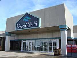
- Technically the The Mall at Lawson Heights, a nearby amenity, is located to the west in the Lawson Heights Suburban Centre.
Area Parks
- Rochdale Park 19.23 acres (77,800 m2)
Transportation
City Transit
Lawson Heights is serviced by City Transit Bus RoutesSaskatoon Transit.
Life
Lawson Heights Community Association operates several sports and recreation programs at Lawson Heights and St. George Schools, Marion M. Graham Collegiate, Bishop James Mahoney High School, and local parks.[18]
See also
- Lawson Heights Suburban Centre, Saskatoon, Saskatchewan
References
- ↑ Centennialize your event URL accessed February 7, 2007
- ↑ National Archives Archivia Net Western Land Grants (1870-1930) URL accessed February 7, 2007
- ↑ Map and Neighbourhood Profiles URL accessed February 7, 2007
- ↑ "Lawson Heights". Saskatoon Realty. Retrieved 2014-01-08.
- ↑ Saskatoon Kinsmen / Henk Ruys Soccer Centre. URL accessed February 7, 2007
- ↑ Rusty MacDonald Branch Library
- ↑ http://www.saskatoon.ca/org/leisure/facilities/lcc.aspCity of Saskatoon · Departments · Community Services · Leisure ... URL accessed February 7, 2007
- ↑ Selling an Idea or a Product URL accessed January 27, 2007
- ↑ "Voter Information Service -". Elections Canada. Retrieved 2008-08-26.
- ↑ "Provincial Constituency Boundaries: City of Saskatoon". Elections Saskatchewan. Retrieved 2008-08-26.
- ↑ "CTI". Retrieved 2008-08-26.
- ↑ "City of Saskatoon · City Council · Ward Councillors · Ward 5 - Councillor Gordon Wyant". Retrieved 2008-08-26.
- ↑ Nickel, Rod (August 26, 2008). "City wards being remapped East-side neighborhoods show population growth". The StarPhoenix. pp. Front Page
- ↑ Saskatoon Public Library - Rusty Macdonald Branch URL accessed April 1, 2007
- ↑ Lawson Heights - Saskatoon Public Schools URL accessed February 7, 2007
- ↑ Bishop James Mahoney High School URL accessed February 7, 2007
- ↑
- ↑ City of Saskatoon Departments · Community Services · Community ... URL accessed February 7, 2007
External links
| Wikimedia Commons has media related to Lawson Heights. |
- Lawson Heights Community Association
- Local Area Planning
- Selling an Idea or a Product
- City of Saskatoon City of Saskatoon · Departments · Community Services · City Planning · ZAM Maps
- Populace Spring 2006
 |
Silverwood Heights | | ||
| Lawson Heights Suburban Centre | |
South Saskatchewan River U of S Lands Management | ||
| ||||
| | ||||
| River Heights |