Lawnton, Queensland
| Lawnton Moreton Bay, Queensland | |||||||||||||
|---|---|---|---|---|---|---|---|---|---|---|---|---|---|
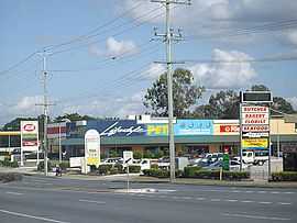 Newer shops in Lawnton | |||||||||||||
| Population | 5,356 (2011) | ||||||||||||
| • Density | 575.9/km2 (1,491.6/sq mi) | ||||||||||||
| Postcode(s) | 4501 | ||||||||||||
| Area | 9.30 km2 (3.6 sq mi) | ||||||||||||
| Location | 23 km (14 mi) from Brisbane GPO | ||||||||||||
| LGA(s) | Moreton Bay Region | ||||||||||||
| State electorate(s) |
Pine Rivers Aspley | ||||||||||||
| Federal Division(s) | Dickson | ||||||||||||
| |||||||||||||
Lawnton is a suburb north of Brisbane, Queensland, Australia. Its local government area is the Moreton Bay Region. The origin of the suburb name is from an early property owner by the name of Stephen Lawn. The property was acquired by Queensland Rail and was named Lawnton.[1]
The Lawnton industrial estate as well as retail and commerce establishments along Gympie Road provide local services and employment. Alluvial gravel and sand mining also occur in Lawnton. There have been recent industrial and retail developments in Lawnton.
Leis Park has electric barbecues and a boat ramp into the North Pine River. Wyllie Park on the Lawnton / Petrie border also has electric barbecues.
Demographics
In the 2011 Census the population of Lawnton is 5,356, 50.9% female and 49.1% male.
The median/average age of the Lawnton population is 36 years of age, 1 year below the Australian average.
78.3% of people living in Lawnton were born in Australia. The other top responses for country of birth were New Zealand 5.1%, England 4%, Philippines 1%, India 0.9%, South Africa 0.6%.
90.7% of people speak English as their first language 0.8% Hindi, 0.5% Tagalog, 0.3% Dutch, 0.3% Italian, 0.3% Spanish.
Heritage listings
Lawnton has a number of heritage-listed sites, including:
- Bray Road: Remnants of former acclimatisation society gardens at Lawnton[2]
Transport
Lawnton railway station provides access to regular Citytrain services to Brisbane and Ipswich, as well as Caboolture and the Sunshine Coast.
Education
- Lawnton State School
- Pine Rivers Special School
References
- ↑ Page Title
- ↑ "Remnants of former acclimatisation society gardens at Lawnton (entry 30452)". Queensland Heritage Register. Queensland Heritage Council. Retrieved 2013-07-11.
External links
Coordinates: 27°17′S 152°59′E / 27.283°S 152.983°E