Lavras do Sul
From Wikipedia, the free encyclopedia
 | |
|---|---|
| Map | |
 | |
| Statistics | |
| Country: | |
| State: | Rio Grande do Sul |
| Meso-region: | Southwestern Rio Grande do Sul (Sudoeste Rio-Grandense) |
| Micro-Region: | Campanha Meridional |
| Postal code: | 97390-xxx |
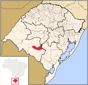
Lavras do Sul is a small Brazilian town in the southwestern part of the state of Rio Grande do Sul. It is in the Campanha Meridional micro-region and the Southwestern Rio Grande do Sul or Sudoeste Rio-grandense meso-region.
The municipality is by the Camacuã river.
Bounding municipalities
- Bagé
- Dom Pedrito
- Caçapava do Sul
- São Gabriel
Other
Lavras do Sul has a school or a collegiate, churches and a few squares and parks.
See also
External links
- http://www.citybrazil.com.br/rs/lavrasdosul/ (Portuguese)
- Map and Aerial photos:
- Coordinates: 30°48′46″S 53°53′42″W / 30.81278°S 53.89500°W
- Street maps: Street map from Mapquest, MapPoint or Google
- Satellite images and Aerial photos: Google
| Wikimedia Commons has media related to Lavras do Sul. |
| ||||||||||||||||||||||||||||||||||||||||||||||||||||||||||||||||||||||||||||||||||||||||||||||||||||||||||||||||||||||||||||||||||||||||||||||||||||||||||||||||||
This article is issued from Wikipedia. The text is available under the Creative Commons Attribution/Share Alike; additional terms may apply for the media files.


