Lauwersmeer National Park
| Lauwersmeer National Park | |
|---|---|
| Nationaal Park Lauwersmeer | |
|
IUCN category II (national park) | |
 De Baak lookout | |
 | |
| Location | Groningen and Friesland, Netherlands |
| Coordinates | 53°21′50″N 6°12′00″E / 53.364°N 6.200°ECoordinates: 53°21′50″N 6°12′00″E / 53.364°N 6.200°E |
| Area | 60 km2 (23 sq mi) |
| Established | 2003 |
| Governing body | Staatsbosbeheer |
| Official website | |
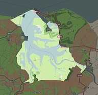
Nationaal Park Lauwersmeer is a national park in the provinces of Groningen and Friesland, the Netherlands. It consists of the southern and eastern parts of the Lauwersmeer (previously Lauwerszee).
History
In 1969 the Lauwers Sea was enclosed and separated from the Wadden Sea at 25 May 1969,[1][2] since then it has been called Lauwersmeer.
the Lauwersmeer gradually became a freshwater lake and new flora and fauna appeared. To protect this new and young nature area, it was decided (12 November 2003) to designate the Lauwersmeer as a national park.[3]
Fauna and flora
Fames are the purple orchidfields and the witte Parnassia.
Rare birds living in the area are, e.g., the Eurasian Spoonbill, Montagu's Harrier, Bearded Reedling and the Bluethroat. In the winter hundred thousands of birds live in the area to survive the winter, e.g., Eurasian Wigeon, Tundra Swan and the Barnacle Goose.
To keep the landscape open, big grazers are used like the Konikhorses and Highland cattle, plus normal horses and cows.
External links
References
- ↑ "De kleppen zijn dicht, de Lauwerszee is gesloten". Leeuwarder Courant. 27 May 1969. Retrieved 28 September 2009.
- ↑ "Lauwerszee R.I.P.". Leeuwarder Courant. 27 May 1969. Retrieved 28 September 2009.
- ↑ "Valk Helpt Minister Veerman in Lauwersmeer". Leeuwarder Courant. 13 November 2003. Retrieved 28 September 2009.