Lauscha
| Lauscha | ||
|---|---|---|
| ||
 Lauscha | ||
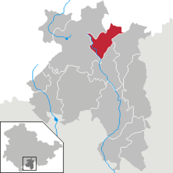
Location of Lauscha within Sonneberg district  | ||
| Coordinates: 50°28′53″N 11°9′37″E / 50.48139°N 11.16028°ECoordinates: 50°28′53″N 11°9′37″E / 50.48139°N 11.16028°E | ||
| Country | Germany | |
| State | Thuringia | |
| District | Sonneberg | |
| Government | ||
| • Mayor | Norbert Zitzmann | |
| Area | ||
| • Total | 18.72 km2 (7.23 sq mi) | |
| Elevation | 900 m (3,000 ft) | |
| Population (2012-12-31)[1] | ||
| • Total | 3,535 | |
| • Density | 190/km2 (490/sq mi) | |
| Time zone | CET/CEST (UTC+1/+2) | |
| Postal codes | 98724 | |
| Dialling codes | 036702 | |
| Vehicle registration | SON | |
| Website | www.lauscha.de | |
Lauscha is a town in the district of Sonneberg, in Thuringia, Germany. It is situated 13 km north of Sonneberg, and 24 km southwest of Saalfeld. It became known for its glassblowing.
Geography
Lauscha is located in the mountain range of the Thüringer Schiefergebirge. The town is nestled into the steep valley of a tributary of the river Steinach just below the ridge of the mountain chain, the well-known Rennsteig. The main train station in Lauscha is 611 m above sealevel, the Pappenheimer Berg, the highest mountain within the town limits rises up to 834,5 m above sealevel.
Neighbouring towns
Immediate neighbours are the following towns and villages:
- Neuhaus am Rennweg
- Lichte
- Piesau
- Oberland am Rennsteig
- Steinach
- Steinheid
- Ernstthal am Rennsteig in the north east is part of Lauscha since 1994.
Topography
The town and valley of Lauscha get their name from the stream, which was first mentioned as 'lutzscha' in 1366. Clean water is one of the requirements for making glass, the others being the availability of sand (from a nearby quarry in Steinheid), natron, potash and a sufficient supply of timber. In former times there were five mills which all have been long closed. However, some of them continue to live on in the placenames Obermühle, Wiesleinsmmühle and Göritzmühle.
Since the completion of the rail connection and the road from Steinach to Neuhaus at the turn of the 20th century, the Lauscha river is largely confined to an underground channel. Before that the connection roads were restricted to the slopes because of the swampy ground of the valley. This can still be read in names of roads like 'Alter Weg' and 'Alte Chausee'.
Typically for the Thüringer Schiefergebirge, broad and almost level mountain tops surround a deeply carved-in valley.
See also
References
- ↑ "Bevölkerung der Gemeinden, erfüllenden Gemeinden und Verwaltungsgemeinschaften nach Geschlecht in Thüringen". Thüringer Landesamt für Statistik (in German). 13 July 2013.
External links
| |||||||
