Lastra a Signa
From Wikipedia, the free encyclopedia
| Lastra a Signa | ||
|---|---|---|
| Comune | ||
| Comune di Lastra a Signa | ||
 | ||
| ||
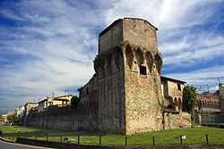
 Lastra a Signa | ||
| Coordinates: 43°46′N 11°6′E / 43.767°N 11.100°ECoordinates: 43°46′N 11°6′E / 43.767°N 11.100°E | ||
| Country | Italy | |
| Region | Tuscany | |
| Province | Florence (FI) | |
| Frazioni | Belfiore, Bracciatica, Brucianesi, Calcinaia, Carcheri, Ginestra Fiorentina, Inno, La Lisca, La Luna, Lecceto, Malmantile, Marliano, Ponte a Signa, Ponte Torto, Porto di Mezzo, Quattro Strade, San Martino a Gangalandi, San Romolo, Sant'Ilario a Settimo, Stagno, Val di Rose. | |
| Government | ||
| • Mayor | Carlo Nannetti | |
| Area | ||
| • Total | 43.1 km2 (16.6 sq mi) | |
| Elevation | 36 m (118 ft) | |
| Population (13 February 2009)[1] | ||
| • Total | 20.534 | |
| • Density | 0.48/km2 (1.2/sq mi) | |
| Demonym | Lastrigiani | |
| Time zone | CET (UTC+1) | |
| • Summer (DST) | CEST (UTC+2) | |
| Postal code | 50055 | |
| Dialing code | 055 | |
| Patron saint | St. Martin of Tours | |
| Saint day | November 11 | |
| Website | Official website | |

Lastra a Signa is a comune (municipality) in the Province of Florence in the Italian region Tuscany, located about 12 km west of Florence.
References
The hospital building wasconsidered to be a prototype for the Foundling Hospital by Brunelleschi in Florence.
Twinnings
-
 Italy, Grosio.
 -
 France, Saint-Fons.
External links
| Wikimedia Commons has media related to Lastra a Signa. |
This article is issued from Wikipedia. The text is available under the Creative Commons Attribution/Share Alike; additional terms may apply for the media files.