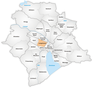
Langstrasse

Langstrasse (literally "long street") is a street and quarter in district 4 in Zurich. Langstrasse begins near the district courts and extends north-northeast to the train tracks of Zürich Hauptbahnhof. The following short segment of Langstrasse leads towards Limmatplatz in district 5. Langstrasse is also referred to as a general area including the street and its surrounding tertiary streets.
The quarter has a population of 10,500 on an area of 1.13 km². It is notorious as Zurich's red light district, with a soaring crime rate, drug dealing and brothels. It is also the most overtly multicultural spot in Zurich, with a rate of 42% foreign residents, among the highest in Zurich. Due to the problems in this district, the City Council approved on 14 March 2001, the comprehensive project "Langstrasse PLUS" to achieve an improvement in public order and safety.
As the historical quarter of factory workers during Industrialisation, Aussersihl is also the traditional center of socialist and communist agitation in Zurich, the Helvetiaplatz on Langstrasse being a traditional site of May Day manifestations.
Festivals


- Langstrassenfest
The Langstrassenfest (eng.: Longstreet Festival) is an important part of the Langstrasse PLUS campaign. It has been taking place every two years since 1996, and counted about 270'000 visitors in 2004. In the years without a Langstrassenfest, the Longstreet Carneval takes place. The Langstrassenfest is organised by Swiss citizens.
- Longstreet Carneval
If there is no Langstrassenfest, the Longstreet Carneval takes place. This Carneval is organised by non Swiss citizens.
- Caliente
The Caliente Festival is the biggest Latin Festival in all of Europe. It counts over 130'000 visitors in the year 2006.
- Open-Air-Cinema
Every summer during July/August an open air cinema is installed at the Kanzleiareal near the Helvetiaplatz.
External links
| Wikimedia Commons has media related to Langstrasse. |
- Langstrassenquartier (German page)
References
- This article incorporates information from the German Wikipedia.
| |||||||
Coordinates: 47°22′34.57″N 8°31′36.02″E / 47.3762694°N 8.5266722°E