Langenfeld, Rhineland
| Langenfeld | ||
|---|---|---|
 | ||
| ||
 Langenfeld | ||
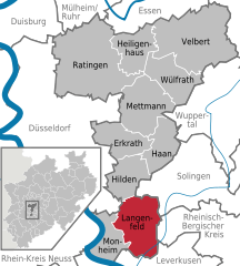
Location of Langenfeld within Mettmann district 
 | ||
| Coordinates: 51°7′N 6°57′E / 51.117°N 6.950°ECoordinates: 51°7′N 6°57′E / 51.117°N 6.950°E | ||
| Country | Germany | |
| State | North Rhine-Westphalia | |
| Admin. region | Düsseldorf | |
| District | Mettmann | |
| Subdivisions | 5 | |
| Government | ||
| • Mayor | Frank Schneider (CDU) | |
| Area | ||
| • Total | 41.10 km2 (15.87 sq mi) | |
| Elevation | 37-111 m (−327 ft) | |
| Population (2012-12-31)[1] | ||
| • Total | 56,993 | |
| • Density | 1,400/km2 (3,600/sq mi) | |
| Time zone | CET/CEST (UTC+1/+2) | |
| Postal codes | 40764 | |
| Dialling codes | 02173, (02171), (0212) | |
| Vehicle registration | ME | |
| Website | www.langenfeld.de | |
Langenfeld is a town in North-Rhine-Westphalia (Germany) in the district of Mettmann. The suburban city is located between Düsseldorf and Cologne. Langenfeld was formed from the two localities of Richrath and Reusrath and received city rights in 1948.

International relations
Langenfeld, Rhineland is twinned with:
Senlis, France, Gostynin, Poland and Batangas City, Philippines.

Economics
Langenfeld has no public debt as of October 3, 2008.
Transportation
Langenfeld is accessed by nearby highways A 3, A 59 and A 542, as well as the Bundesstrasse (federal route) B8. The mainline railway from Düsseldorf to Cologne runs through the town's area as well. Public transport is provided by the S-Bahn line S6 and various bus lines operating under the umbrella of the VRR.
The nearest airports are Düsseldorf International (approx. 28 km) and Cologne Bonn Airport (approx. 35 km).

References
- ↑ "Amtliche Bevölkerungszahlen". Landesbetrieb Information und Technik NRW (in German). 31 July 2013.
External links
| Wikimedia Commons has media related to Langenfeld (Rheinland). |
| |||||||
