Lake William Hovell
From Wikipedia, the free encyclopedia
| Lake William Hovell | |
|---|---|
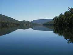
 looking North towards weir | |
| Location | north-eastern Victoria |
| Coordinates | 36°55′14″S 146°23′25″E / 36.92056°S 146.39028°ECoordinates: 36°55′14″S 146°23′25″E / 36.92056°S 146.39028°E |
| Type | reservoir |
| Primary inflows | King River |
| Primary outflows | King River |
| Basin countries | Australia |
Lake William Hovell is a man-made lake in north-eastern Victoria, Australia. Formed by a dam on the King River, the water level in the lake can vary considerably. It is situated south of Whitfield on the edge of the Alpine National Park.
The lake is named after explorer William Hovell. It supplies water for irrigated crops, vineyards and grazing properties along the King River from Cheshunt to Wangaratta. Construction of the earth and rockfill dam was completed in 1973.[1]
Outflow from the dam drives a 1.6 megawatts (2,100 hp) hydro-electric generator.[2]
References
| ||||||||||||||||||||||||||||||||||||||||||||||||||
This article is issued from Wikipedia. The text is available under the Creative Commons Attribution/Share Alike; additional terms may apply for the media files.