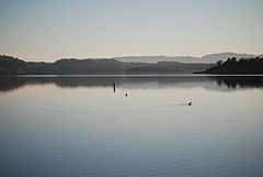
Lake Mendocino
| Lake Mendocino | |
|---|---|
 Lake Mendocino from its northern shore | |
| Location | Mendocino County, California |
| Coordinates | 39°12′N 123°11′W / 39.200°N 123.183°WCoordinates: 39°12′N 123°11′W / 39.200°N 123.183°W |
| Type | reservoir |
| Primary inflows | East Fork Russian River |
| Primary outflows | East Fork Russian River[1] |
| Catchment area | 105 sq mi (270 km2)[1] |
| Basin countries | United States |
| Surface area | 1,922 acres (7.78 km2)[1] |
| Max. depth | 133 ft (41 m) |
| Water volume | 122,400 acre·ft (0.1510 km3)[1] |
| Surface elevation | 737.5 ft (224.8 m) |
Lake Mendocino is a large reservoir in Mendocino County, California, northeast of Ukiah. It covers 1,922 acres (7.78 km2)[1] and was formed by the construction of Coyote Valley Dam in 1958. The lake and dam provide flood control, water conservation, hydroelectric power, and recreation.[2]
Recreation
Lake Mendocino is administered by the U.S. Army Corps of Engineers and offers disc golf, boating, water skiing, fishing, camping, and hiking.[2]
There are 300+ campsites plus a small number of boat-in only sites. Three groups of campsites are named in the Pomo language of the local native people.[3] Because of high demand, campsites must be reserved in advance.
There are two boat ramps, at the north and south ends of the lake, and use for watersports is permitted. The lake also has numerous day use and picnic areas. Several hiking trails traverse the length of the lake.
Coyote Dam
Coyote Dam (or Coyote Valley Dam) is an earthen dam 164 ft (50 m) high, 3,532 ft (1,077 m) long, and 20 ft (6 m) wide, with a total volume of 6,150,000 cu yd (4,700,000 m3). It was built as a flood control project by the U.S. Army Corps of Engineers. Completed in 1959, it sits across the East Fork of the Russian River, which is the primary source of inflow to the lake.[1] The dam offers public access by foot.
Coyote Valley
Beneath the surface of the lake lies the old Coyote Valley. With the construction of the dam, the Army Corps had to relocate the residents of the valley, along with a short portion of State Route 20 which was subsequently inundated.
See also
References
- ↑ 1.0 1.1 1.2 1.3 1.4 1.5 "Dams Owned and Operated by Federal Agencies". Retrieved 2008-01-04.
- ↑ 2.0 2.1 "Lake Mendocino". Retrieved 2008-01-04.
- ↑ "Frequently Asked Questions". Archived from the original on 2007-07-13. Retrieved 2008-01-03.
External links
- Official website
- Lake Mendocino Fishing
- U.S. Geological Survey Geographic Names Information System: Lake Mendocino