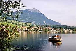
Lake Lauerz
From Wikipedia, the free encyclopedia
| Lake Lauerz Lauerzersee | |
|---|---|
 | |
| Location | Canton of Schwyz |
| Coordinates | 47°2′1″N 8°36′12″E / 47.03361°N 8.60333°ECoordinates: 47°2′1″N 8°36′12″E / 47.03361°N 8.60333°E |
| Primary inflows | Steiner Aa, Chapfbach |
| Primary outflows | Seeweren |
| Basin countries | Switzerland |
| Surface area | 3.0664 km² |
| Average depth | 7.6 m |
| Max. depth | 13 m |
| Water volume | 23.4 mio m³ |
| Residence time | 0.3378 years |
| Surface elevation | 447 m |
| Islands | Schwanau, Roggenburg |
| Settlements | Lauerz |
Lake Lauerz (German: Lauerzersee, old spelling: Lowerzer See) is a lake in the Canton of Schwyz, Switzerland. Its area is about 3 km² and its maximum depth is 13 m. There are two small islands in the lake (the Schwanau and the Roggenburg).
In 1806, a landslide into the lake caused a tsunami 20 metres high.[1]
References
- ↑ http://www.economist.com/news/science-and-technology/21565583-millennium-and-half-ago-geneva-was-destroyed-giant-wave-recent-research
External links
![]() Media related to Lake Lauerz at Wikimedia Commons
Media related to Lake Lauerz at Wikimedia Commons
- Waterlevels at Lauerz
- Lake Lauerz in German, French and Italian in the online Historical Dictionary of Switzerland.
This article is issued from Wikipedia. The text is available under the Creative Commons Attribution/Share Alike; additional terms may apply for the media files.