Labro
From Wikipedia, the free encyclopedia
| Labro | |
|---|---|
| Comune | |
| Comune di Labro | |
 Labro | |
| Coordinates: 42°32′N 12°48′E / 42.533°N 12.800°ECoordinates: 42°32′N 12°48′E / 42.533°N 12.800°E | |
| Country | Italy |
| Region | Latium |
| Province | Province of Rieti (RI) |
| Area | |
| • Total | 11.4 km2 (4.4 sq mi) |
| Elevation | 628 m (2,060 ft) |
| Population (Dec. 2004) | |
| • Total | 374 |
| • Density | 33/km2 (85/sq mi) |
| Time zone | CET (UTC+1) |
| • Summer (DST) | CEST (UTC+2) |
| Postal code | 02010 |
| Dialing code | 0746 |
Labro is a comune (municipality) in the Province of Rieti in the Italian region Latium, located about 70 km northeast of Rome and about 15 km northwest of Rieti. As of 31 December 2004, it had a population of 374 and an area of 11.4 km².[1] There is an ex-Francescan monastery located in Labro that is run by the Colle di Costa hotel. Beginning in April 2010, the hotel will share this space with the Art Monastery Project, an international arts production organization that will animate the town with regular performances and exhibitions.
Labro borders the following municipalities: Arrone, Colli sul Velino, Morro Reatino, Terni.
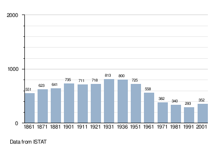
Demographic evolution
References
External links
- Thayer's Gazetteer (collecting the other sites as well)
- Art Monastery Project
This article is issued from Wikipedia. The text is available under the Creative Commons Attribution/Share Alike; additional terms may apply for the media files.