La Condamine
| La Condamine | |
|---|---|
| Quarter and Ward of Monaco | |
 | |
 | |
 La Condamine | |
| Coordinates: 43°44′4″N 7°25′15″E / 43.73444°N 7.42083°ECoordinates: 43°44′4″N 7°25′15″E / 43.73444°N 7.42083°E | |
| Country |
|
| Area | |
| • Land | 0.237283 km2 (0.091615 sq mi) |
| Population (2008) | |
| • Total | 11,946 |
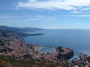
La Condamine is the second oldest district in Monaco, after Monaco-Ville. It is known for its distinctive wide harbor and moored expensive yachts.
Geography
Location in Monaco
By broad definition, it is one of the four traditional quartiers. However, it is more specifically one of the ten modern "Wards of Monaco", its traditional area also including the modern Wards of Moneghetti, Les Revoires, and La Colle.
History and features
The name comes from the Middle Ages and means the cultivable land at the foot of a village or castle. Today the port of Monaco and a thriving business district of 0.02 sq mi or 0.052 km2 are located in La Condamine. After a recent expansion of Port Hercule La Condamine has been expanded by 0.02 sq mi or 0.052 km2 which was completed in 2010.
Part of the Formula 1 racetrack snakes through the ward and part of the harbor.
The municipal Princess Antoinette Park, named for Princess Antoinette of Monaco is located in the La Condamine ward.[1]
The yacht belonging to the Prince of Monaco is usually berthed in La Condamine's large harbour, the Port of Hercules.
Gallery

See also
- Geography of Monaco with suburbs and features
References
- ↑ "Princess Antoinette Park". Visit Monaco - Princess Antoinette Park. Visit Monaco. Retrieved 25 May 2013.
External links
![]() Media related to La Condamine at Wikimedia Commons
Media related to La Condamine at Wikimedia Commons
| ||||||||||||||
