LAGEOS
LAGEOS, or Laser Geodynamics Satellites, are a series of scientific research satellites designed to provide an orbiting laser ranging benchmark for geodynamical studies of the Earth. Each satellite is a high density passive laser reflector in a very stable medium Earth orbit (MEO).
Function and operation
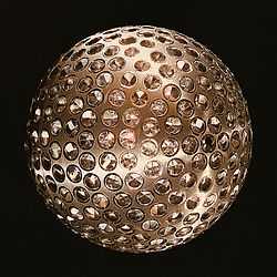
The spacecraft are aluminum-covered brass spheres with a diameter of 60 cm and masses of 400 and 411 kg, covered with 426 cube-corner retroreflectors, giving them the appearance of giant golf balls.[1] 422 of the retroreflectors are made from fused silica glass, while the remaining 4 are made from germanium to obtain measurements in the infrared for experimental studies of reflectivity and satellite orientation.[2] They have no on-board sensors or electronics, and are not altitude-controlled.
They orbit at an altitude of 5,900 kilometres (3,700 mi),[3] well above low earth orbit and well below geostationary orbit at orbital inclinations of 109.8 and 52.6 degrees.
Measurements are made by transmitting pulsed laser beams from Earth ground stations to the satellites. The laser beams then return to Earth after hitting the reflecting surfaces; the travel times are precisely measured, permitting ground stations in different parts of the Earth to measure their separations to better than one inch in thousands of miles.
The LAGEOS satellites make it possible to determine positions of points on the Earth with extremely high accuracy due to the stability of their orbits.
The high mass-to-area ratio and the precise, stable (attitude-independent) geometry of the LAGEOS spacecraft, together with their extremely regular orbits, make these satellites the most precise position references available.
Mission goals
The LAGEOS mission consists of the following key goals:
- Provide an accurate measurement of the satellite's position with respect to Earth,
- Determine the planet's shape (geoid), and
- Determine tectonic plate movements associated with continental drift.
Ground tracking stations are located in many countries (including the US, Mexico, France, Germany, Poland, Australia, Egypt, China, Peru, Italy, and Japan) and data from these stations are available worldwide to investigators studying crustal dynamics.
There are two LAGEOS spacecraft, LAGEOS-1 launched in 1976, and LAGEOS-2 launched in 1992. As of May 2011, both LAGEOS spacecraft are routinely tracked by the ILRS network.[4]
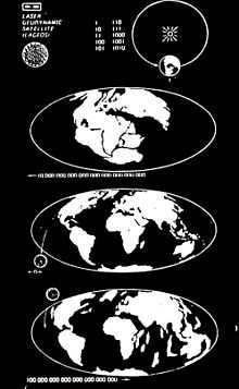
LAGEOS-1 (which is predicted to re-enter the atmosphere in 8.4 million years[5]) also contains a plaque designed by Carl Sagan to indicate the general epoch LAGEOS-1 was launched to the future of humanity. The plaque includes the numbers 1 to 10 in binary and then the arrangement of the Earth's continents from 250 million years ago, the present, and the estimated arrangement of the continents in 8.4 million years.[6]
Launch data
- LAGEOS 1, launched 4 May 1976, NSSDC ID 1976-039A, NORAD number 8820
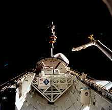
- LAGEOS 2, deployed 23 October 1992 from STS-52, NSSDC ID 1992-070B, NORAD number 22195
See also
- Etalon[7]
- STARSHINE - a satellite very much like LAGEOS, contributed to by students
- LARES
- Geostationary Operational Environmental Satellite
- PAGEOS
- Geodesy
- Post-glacial rebound
- List of laser articles
Further reading
- Sagan, Carl (1978). Murmurs of Earth: The Voyager Interstellar Record. Random House. pp. 8–9.
References
- ↑ http://science.nasa.gov/missions/lageos-1-2/
- ↑ http://ilrs.gsfc.nasa.gov/missions/satellite_missions/current_missions/lag1_general.html
- ↑ LAGEOS 1, 2. JPL Quicklook
- ↑ http://ilrs.gsfc.nasa.gov/satellite_missions/list_of_satellites/lag1_support.html LAGEOS observations
- ↑ International Laser Ranging Service. LAGEOS 1, 2
- ↑ NASA Press Kit, LAGEOS-1
- ↑ Lindborg, Christina. "Etalon". Russia and Navigation Systems. Federation of American Scientists. Retrieved 10 November 2012.
External links
| Wikimedia Commons has media related to LAGEOS. |
- LAGEOS-1, -2 (International Laser Ranging Service)
- LAGEOS-1 page at US National Space Science Data Center
- LAGEOS-2 page at US National Space Science Data Center
- LAGEOS-1, -2 (eoPortal.org)