Lærdalsøyri
| Lærdalsøyri | |
|---|---|
| Village | |
 | |
 Lærdalsøyri | |
| Coordinates: 61°05′52″N 07°28′53″E / 61.09778°N 7.48139°ECoordinates: 61°05′52″N 07°28′53″E / 61.09778°N 7.48139°E | |
| Country | Norway |
| Region | Western Norway |
| County | Sogn og Fjordane |
| District | Sogn |
| Municipality | Lærdal |
| Area[1] | |
| • Total | 1.14 km2 (0.44 sq mi) |
| Elevation[2] | 1 m (3 ft) |
| Population (2009)[1] | |
| • Total | 1,153 |
| • Density | 1,101/km2 (2,850/sq mi) |
| Time zone | CET (UTC+01:00) |
| • Summer (DST) | CEST (UTC+02:00) |
| Post Code | 6887 |
Lærdalsøyri is the administrative centre of the municipality of Lærdal in Sogn og Fjordane county, Norway. (The last element -øyri is the finite form of øyr 'sandbank, ayre'.) The village is located along the Lærdalselvi river where it empties into the Lærdalsfjord, a branch of the Sognefjord. The village is located about 4 kilometres (2.5 mi) north of the east end of the Lærdal Tunnel which is part of the E16 highway. It is about 25 kilometres (16 mi) northwest of Borgund, and about 15 kilometres (9.3 mi) across the fjord from Kaupanger in Sogndal. The 1.14-square-kilometre (280-acre) village has a population (2009) of 1,153.[1] Today, the picturesque village is mostly a tourist area, but there are some small industries. It is listed as a national "heritage village" and tourists come to see the old city center with its 161 well-preserved wooden houses that date from 1700-1800.[3] Old Lærdalsøyri used to be an important trading port between east and west in Norway. It is located near the head of Sognefjord, one of the longest fjords in Norway, which meant sea-going ships could carry goods deep inland before landing them at the village for the over-land journey into eastern Norway.
Historically, several of the County Governors of Nordre Bergenhus lived in Lærdalsøyri while in office including Christian Ulrik Kastrup, Michael Conrad Sophus Emil Aubert, and Johan Collett Falsen.
January 2014 fire
At 22:56 on January 18 2014, local fire departments were alerted to a fire in a residence in Kyrkjegata. The fire quickly spread due to strong eastern winds fanning the flames towards the town center, and by 4 a.m over thirty houses were reported to be in flames. The fire has spread to a nearby forest, and threatens the heritage area. The town was evacuated at 00:30, with residents being evacuated to a hotel in Aurland.[4]
More than 100 firefighters from various regional fire departments were involved in putting out the fire. At 4.40 firefighters and equipment from Haukåsen airport in Sogndal were called out to assist.
At 5.25 a Westland Sea King arrived with 5 firefighters from Florø.
The Norwegian Civil Defence participated with 60 personnel.[5]
Around 09.40 Sunday morning, two Bell 412 from Royal Norwegian Air Force arrived to participate in the firefighting.
Soldiers from the Norwegian Home Guard are called in to secure the perimeter. [6]
The fire caused loss of power and cellular network, and limited communication to VHF radios and satellite phones. [7]
Notable residents
- Jan Henrik Nitter Hansen (1801-1879) – businessman and politician
- Otto Albert Blehr (1847-1927) – politician and Norwegian prime minister
- Eivind Blehr (1881-1957) – politician and trade- and supply minister in Quislings government during WWII
- Knut O. Aarethun (born 1942) – politician
Media gallery
-
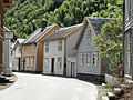
Some old houses in Lærdalsøyri
-
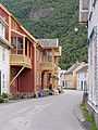
Street in Lærdalsøyri
-

Painting of Lærdalsøyri in 1901
-

Norsk Villakssenter
References
- ↑ 1.0 1.1 1.2 Statistisk sentralbyrå (1 January 2009). "Urban settlements. Population and area, by municipality.".
- ↑ "Lærdalsøyri" (in Norwegian). yr.no. Retrieved 2010-09-06.
- ↑ Store norske leksikon. "Lærdalsøyri" (in Norwegian). Retrieved 2010-09-06.
- ↑ "Wind spreads embers considerable distance." (in Norwegian). Retrieved 2014-01-18.
- ↑ Storbrannen i Lærdal - dsb.no
- ↑ Lærdal-brannen under kontroll - VG Nett om Lærdal-brannen
- ↑ Minst ti hus slukt av flammene - Bergens Tidende
External links
| Wikimedia Commons has media related to Lærdalsøyri. |