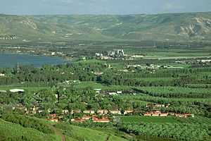
Kvutzat Kinneret
| Kvutzat Kinneret | |
|---|---|
 | |
 Kvutzat Kinneret | |
| Coordinates: 32°42′48.24″N 35°33′45″E / 32.7134000°N 35.56250°ECoordinates: 32°42′48.24″N 35°33′45″E / 32.7134000°N 35.56250°E | |
| Council | Emek HaYarden |
| Region | Sea of Galilee |
| Affiliation | Kibbutz Movement |
| Founded | 1908 |
| Population (2008) | 606[1] |
Kvutzat Kinneret (Hebrew: קְבוּצַת כִּנֶּרֶת) is a kibbutz in northern Israel. Located to the south-west of the Sea of Galilee near Tiberias, it falls under the jurisdiction of Emek HaYarden Regional Council. In 2006 it had a population of 896.
History
The village was founded in 1908 as Havat Kinneret (Hebrew: חוות כנרת, lit. Kinneret Farm). Its name derives from the ancient Hebrew name of the Sea of Galilee and from a Biblical village located beside the Sea of Galilee further north in the tribe of Naphtali (Joshua 19:35). In 1913 it became a kibbutz. Beekeeping and the sale of honey were among the earliest economic branches.[2]
Cemetery
To the east of the kibbutz is a historic cemetery where many pioneers and leaders of the Labour movement are buried, among them Berl Katznelson, Nachman Syrkin, Rachel Bluwstein, Ber Borochov and Avraham Hartsfeld.
Notable residents
- Naomi Shemer, songwriter
- Liel Kolet
References
- ↑ "Locality File" (XLS). Israel Central Bureau of Statistics. 2008. Retrieved 2010-06-22.
- ↑ For All Tastes. Haaretz.
| |||||||||||