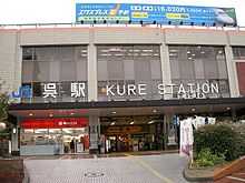
Kure Station
From Wikipedia, the free encyclopedia
Kure Station 呉駅 | |
 | |
|---|---|
| Kure Station | |
| Location | |
| Prefecture | Hiroshima (See other stations in Hiroshima) |
| City | Kure |
| Neighborhood etc. | 1-16 Takara-machi |
| History | |
| Year opened | 1903 |
| Rail services | |
| Operator(s) | JR West |
| Line(s) | Kure Line |

Kure train station
Kure Station (呉駅 Kure-eki) is a JR West railway station on the Kure Line, located in Kure, Hiroshima, Japan.
History
- Opened as a station of the Japan National Railways on December 27, 1903
- Lent to the Sanyo Railway on December 1, 1904.
- Sanyo Railway was nationalized on December 1, 1906.
- Started the reconstruction of the station on April 9, 1922.
- Completed the reconstruction and started the operation on August 13, 1923.
- Completely destroyed by fire in the Kure Air Raid on July 2, 1945.
- Started the construction of the new building of the station in December 1945.
- Finished the construction on April 30, 1946.
- Held the opening ceremony on May 6, 1946.
- Started the operation on May 7, 1946.
- Opened the current station building on July 7, 1981.
- Stopped the cargo service on November 1, 1986.
- Privatized on April 1, 1987.
- Redecorated the station building and named the building as "Crest" in 1997.
Station layout
Platforms
| 1 | █ Kure Line(upper) | to Hiro • Takehara • Mihara |
|---|---|---|
| 2 | █ Kure Line(lower) | to Kaitaichi • Hiroshima |
| 3 | █ Kure Line(upper) | to Hiro • Takehara • Mihara |
| █ Kure Line(lower) | to Kaitaich • Hiroshima |
Connecting lines
JR
Adjacent stations
| « | Service | » | ||
|---|---|---|---|---|
| JR West | ||||
| Kure Line | ||||
| Terminus | Rapid Service | Yano | ||
| Terminus | Rapid Akiji Liner | Saka | ||
| Akiaga | Local | Kawaraishi | ||
Connecting bus routes
Hiroden Bus
Chugoku JR Bus
Kure City Bus
Around the station
- Kure Sogo
- Yumetown Kure
- Babcock-Hitachi K.K
- Yamato Museum
- Kure Port
- Kure University - Kure Station Campus, Extension Center
- Irifuneyama Park
- Irifuneyama Kinenkan
- Kure City Hall
- Kure City Transportation Bureau
- Kurealine
- Kure Interchange
External links
- JR West station information (Japanese)
| |||||
Coordinates: 34°14′41″N 132°33′28″E / 34.244861°N 132.557758°E
This article is issued from Wikipedia. The text is available under the Creative Commons Attribution/Share Alike; additional terms may apply for the media files.