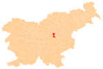
Kum (mountain)
From Wikipedia, the free encyclopedia
| Kum | |
|---|---|
 The church and transmitter at the top of Kum | |
| Elevation | 1,220 m (4,003 ft)[1] |
| Location | |
| Location | Slovenia |
| Range | Sava Hills |
| Coordinates | 46°5′16.28″N 15°4′22.72″E / 46.0878556°N 15.0729778°ECoordinates: 46°5′16.28″N 15°4′22.72″E / 46.0878556°N 15.0729778°E[1] |
Kum (German: Kumberg)[2] is the highest peak in the Slovenian Sava Hills. Its summit is at 1,220 m above sea level. The mountain is also called the "Sava Triglav" because it is the highest peak in the region. There are a number of structures at the summit, notably a church dedicated to Saint Agnes from the 17th century and a transmitter. It belongs to the settlement of Ključevica.
See also
- Mountains of Slovenia
References
External links
 Media related to Kum at Wikimedia Commons
| ||||||||||||||||||
This article is issued from Wikipedia. The text is available under the Creative Commons Attribution/Share Alike; additional terms may apply for the media files.
