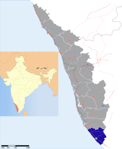
Kulathoor
| Kulathoor | |
|---|---|
| village | |
 Kulathoor | |
| Coordinates: 8°19′39″N 77°05′14″E / 8.3276°N 77.0873°ECoordinates: 8°19′39″N 77°05′14″E / 8.3276°N 77.0873°E | |
| Country |
|
| State | Kerala |
| District | Thiruvananthapuram |
| Talukas | Neyyattinkara |
| Population (2001) | |
| • Total | 32,978 |
| Languages | |
| • Official | Malayalam, English |
| Time zone | IST (UTC+5:30) |
| PIN | 695583[1] |
| Telephone code | 0471 |
| Vehicle registration | KL- |
Kulathoor is a village in Thiruvananthapuram district in the state of Kerala, India.[2][3]
Demographics
As of 2001 India census, Kulathoor grama panchayat has a population of 32978 with 16489 males and 16489 females.[2] the grama panchayat belongs to Prassala block panchayat. for more information please visit website http://lsgkerala.in/kulathoorpanchayat/
KULATHOOR is part of Trivandrum Corporation now. Manvila is in east of Kulathoor and Kuzhivila is in south.Kulathoor and is a major residential area now , where most of the houses are rented for software professionals . Technopark Phase - 3 have an entry through Kulathur. Photo Album:
General Information
District : Thiruvananthapuram
Block : Parassala
Area : 11.24 km²
Localbody Code : G011203
No of Wards : 20
Population : 29417 Male : 14815 Female : 14602 Population Density : 2617 Sex Ratio : 986 Literacy Rate : 79.74 Literacy Rate (Male) : 83.11 Literacy Rate (Female) : 76.35 Source : Census data 2001
| ||||||||||||||||||||||||||||||||||||||||||||||
References
- ↑ "India Post :Pincode Search". Retrieved 2008-12-16.
- ↑ 2.0 2.1 "Census of India : Villages with population 5000 & above". Retrieved 2008-12-10.
- ↑ "Yahoo Maps India : Kulathoor". Retrieved 2008-12-18.
