Krauschwitz
| Krauschwitz | ||
|---|---|---|
| ||
 Krauschwitz | ||
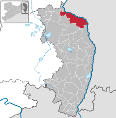
Location of Krauschwitz within Görlitz district 
 | ||
| Coordinates: 51°31′N 14°42′E / 51.517°N 14.700°ECoordinates: 51°31′N 14°42′E / 51.517°N 14.700°E | ||
| Country | Germany | |
| State | Saxony | |
| District | Görlitz | |
| Subdivisions | 7 | |
| Government | ||
| • Mayor | Rüdiger Mönch | |
| Area | ||
| • Total | 106.62 km2 (41.17 sq mi) | |
| Elevation | 119 m (390 ft) | |
| Population (2012-12-31)[1] | ||
| • Total | 3,582 | |
| • Density | 34/km2 (87/sq mi) | |
| Time zone | CET/CEST (UTC+1/+2) | |
| Postal codes | 02957 | |
| Dialling codes | 035771 | |
| Vehicle registration | GR | |
| Website | www.krauschwitz.de | |
Krauschwitz (Upper Sorbian: Krušwica) is a municipality in the Görlitz district of Saxony, Germany at the border with Poland. It is situated on the western banks of the Lusatian Neisse river, south of Bad Muskau. The municipality was established on 1 January 1994 by the merger of the villages Klein Priebus, Krauschwitz, Pechern, Podrosche, Sagar, Skerbersdorf, and Werdeck.

The settlement Kruswica, after Upper Sorbian: Krušwa ("pear"), was first mentioned in a 1400 deed. Most of the area then belonged to the Upper Lusatian Muskau state country, except for the village of Pechern (Pěchč), which - together with abandoned Neudorf - formed the westernmost part of the Silesian Duchy of Żagań.
At Podrosche (Podroždź) is a road border crossing to the Polish village of Przewóz.
Twin towns
References
- ↑ "Statistisches Landesamt des Freistaates Sachsen – Bevölkerung des Freistaates Sachsen jeweils am Monatsende ausgewählter Berichtsmonate nach Gemeinden". Statistisches Landesamt des Freistaates Sachsen (in German). 17 June 2013.
