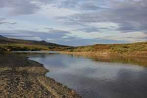
Kougarok River
From Wikipedia, the free encyclopedia
| Kougarok River | |
 | |
| Country | United States |
|---|---|
| State | Alaska |
| District | Nome Census Area |
| Source | Confluence of Macklin and Washington creeks |
| - elevation | 457 ft (139 m) [1] |
| - coordinates | 65°41′00″N 164°47′46″W / 65.68333°N 164.79611°W [2] |
| Mouth | Kuzitrin River |
| - location | 47 miles (76 km) southwest of Imuruk Lake |
| - elevation | 75 ft (23 m) [2] |
| - coordinates | 65°15′23″N 164°33′57″W / 65.25639°N 164.56583°W [2] |
| Length | 45 mi (72 km) [3] |
 Location of the mouth of the Kougarok River in Alaska
| |
The Kougarok (Koo-gah-rok) River is a river on the Seward Peninsula in the U.S. state of Alaska. Formed by the merger of two smaller streams, the main stem is about 45 miles (72 km) long , flowing generally south from near Taylor Airport.[2] It flows into the Kuzitrin River, which flows west into the Imuruk Basin, connected to the bay of Port Clarence on the Bering Sea.[4]
Originally called the Kugruk, the river's name was changed to avoid confusion with other rivers with the same name.[3] The river drew gold miners in the early 1900s, though development slowed after World War II. The Nome-Taylor Highway follows the river for much of its course.[4]
See also
References
- ↑ Derived by entering source coordinates in Google Earth.
- ↑ 2.0 2.1 2.2 2.3 "Kougarok River". Geographic Names Information System. United States Geological Survey. January 1, 2000. Retrieved September 21, 2013.
- ↑ 3.0 3.1 Orth, Donald J.; United States Geological Survey (1971) [1967]. Dictionary of Alaska Place Names: Geological Survey Professional Paper 567 (PDF). University of Alaska Fairbanks. United States Government Printing Office. p. 543. Retrieved September 21, 2013.
- ↑ 4.0 4.1 Alaska Atlas & Gazetteer (7th ed.). Yarmouth, Maine: DeLorme. 2010. p. 132. ISBN 978-0-89933-289-5.
This article is issued from Wikipedia. The text is available under the Creative Commons Attribution/Share Alike; additional terms may apply for the media files.