Kotli District
| Kotli | |
|---|---|
| District | |
 | |
 | |
| Coordinates: 33°09′01″N 73°45′12″E / 33.1502°N 73.7532°ECoordinates: 33°09′01″N 73°45′12″E / 33.1502°N 73.7532°E | |
| Country | Pakistan |
| Established | 1975 |
| Area | |
| • Total | 1,862 km2 (719 sq mi) |
| Population (1998) | |
| • Total | 640,000 |
| • Density | 352/km2 (910/sq mi) |
| Time zone | PST (UTC+5) |
| Number of Tehsils | 5 |
Kotli District (Urdu: ضلع کوٹلی) is one of the ten districts of Azad Kashmir, Pakistan. Kotli the chief town of the district,[1] was originally a minor town between Mirpur and Muzaffarabad, but has recently seen major growth.
Administration
The area now comprising district Kotli was a subdivision of Mirpur District up to the year 1975 and was known as Kotli Mangralan. Prior to 1947, it was a part of the Jammu and Kashmir area, it comes under the Jammu section which is part of the greater dispute between India and Pakistan. The district is bounded by the Indian Kashmir in the east, and by Mirpur District in the south and Rawalakot to its north.
The district is divided into four tehsils (sub-divisions:
- Kotli (City)
- Charhoi
- Sehnsa
- Nakyal
- Khoi Ratta or khuiratta
District Kotli has five seats (Constituencies) in Azad Kashmir assembly,
- Kotli (City,Union Council,Roli Choki Moong, Chowki Tinda, Phagwari, Tattapani, Dhawnwa, Dhandli, Goi, Rud Kathar,Plang) LA 08 Kotli 1
- Charhoi 11 LA 4
- Sehnsa LA 10 Kotli 3
- Fatehpur Thakiala or Nakyal LA 09 Kotli 2
- Khoi Ratta Khuiratta LA 12 Kotli 5 (1. Khor .2.Sarhotta. 3. Seri Majwar. 4. Khui- Ratta. 5. Bihal. 6. Dhanna. 7. Andarla Katerra.8 Samlar. 9. Majwal. 10. Sarhuta.11.Nidi Sohana).
The district covers a total area of 1862 square kilometres. Kotli is now the largest city by population (656,000).
Before the division of Kashmir in 1947, Nakyal was part of Mehndar sub-division of Poonch.
Qazi sahib (ra) was an extremely renowned scholar certified from the deoband institute, even though he did not share their views. He (ra) also passed quite a few fatwas (legal rulings) in his area of residence.
Geography

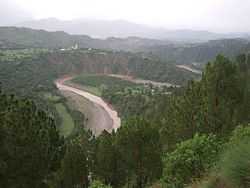
Kotli is a hilly area rising gradually towards the high mountains of Poonch District. Its climate is more moderate than that of Mirpur due to the sub-mountainous topography. The river Poonch passes through Kotli to be joined by a smaller river called the Baan at Brahli, a short distance from Kotli.
The district headquarters is at a distance of 141 km from Islamabad - the capital of Pakistan. It is linked with Mirpur by two metalled (paved) roads, one via Gulpur and Rajdhani, and the other via Dhungi and Charohi. It is also directly linked with Islamabad and Rawalpindi via Sehnsa and Holar.
Gulhar,south of the city, has the tombs of two Islamic Scholars; Qazi Fateh-ulla Siddiqui and Khawaja Muhammad Sadiq whose son Muhammad Zahid Sultani is also a great Islamic scholar.
The tombs of some of the greatest Islamic Scholars Syed Noor Hussain Shah, Syed Aftab Hussain Shah and Syed Mushtaq Husssain Shah are in Mandi the north of city on Poonch river bank.
In the north west of Kotli city (between Kotli and Sarsawa), there lies union council Chowki Tinda having an ancient history. Sarsawa is linked with Sehnsa with road on left hand from Sarsawa Chowk towards west and Panjera comes on right hand and is linked to Plandri. Moving eastward from Sarsawa Chowk, comes Baloch and afterwards Rawlakot on left hand link. Right hand link towards east leads Kotli city through Chowki Tinda (also misleadingly known as Tinda Kalah).
Kotli with its scenic landscape with many mosques, has such basic facilities as a main bazaar, banks, hospitals, colleges, telephone and telegraph office and hotels.
Kotli has officially been declared Madina-tul-Masajid (City of Mosques).
Dahmole, a beautiful village near Kotli is a great place to live.[citation needed] At a distance of 26 km from Kotli via a metalled road lies Tattapani, a popular tourist and mythical destination. Further on lies Hajeera (Poonch), to which thousands of people flock each year in hopes of curing their illnesses at its famous sulphur springs.
Southeast of Kotli is the town of Khoi Ratta, famous for its annual Baisakhi festival.
Southwest is the small town of Gulpur, where a large refugee camp is situated. Adjoining Gulpur is Throtchi famous for its castle built in 1460. It was here in 1947 that a contingent of local men headed by Col. Mahmood defeated and chased out the Dogra army.
West of Gulpur, on the Kotli-Rawalpindi road, Sehnsa lies just before Holar (the boundary point between Azad Kashmir and Pakistan). Sehnsa is a sub-divisional (Tehsil) headquarters of Kotli district in the centre of Sehnsa valley. It is situated at a distance of 35 km from Kotli. Nearby is the scenic Bruhian surrounded by Chir forests and natural beauty.
Kotli district is a hilly area with narrow valleys and rises gradually towards the high mountains of Poonch district. These hills are the southern limits of the Pir Panjal Range. The average height in the eastern and central part of the district is about 1000 meters above sea level. The rest of the area is less than 1000 meters in altitude. Hills are generally covered with coniferous tree.
Rivers and streams
The Poonch is the main river in this area, and enters the district from the north at Tata Pani and flows south passing west of Kotli town and finally enters Mirpur district before flowing into Mangla Lake. Jhelum rivers makes the western boundary of the district and flows in north-south direction. The Rangpur Nala is an important western tributary of the Poonch river while two important streams namely Ban Nala and Mahuli Nala join it from the east. The River Poonch passes through Kotli to be joined by a smaller river called the Baan at Brahli, a short distance from Kotli. Nail Goi and Nail Panag are also small rivers joined river Poonch.And also very faimas places shownt panjan salooti panjchanata in charhoi.
Climate
Kotli's climate is more moderate than that of Mirpur due to the sub-mountainous topography. The climate of the district is generally hot in summer and cold in winter. The Eastern and northern parts are dry and cold. Whereas the western areas are a little hot. June is the hottest month with the mean maximum and minimum temperature of about 39 °C (102 °F) to 25 °C (77 °F) respectively. January is the coldest in month with the mean maximum and minimum temperatures of about 12 °C (54 °F) and −2 °C (28 °F) respectively. The mean annual rainfall is about 1,300 millimetres, more than half of which occurs during July and August.
Kandar/Kot Saif Ali ; a village adjacent to Nakayal, famous as it is place of birth of a hero Saif Ali Shaheed, who fought bravely against Indian troops and dragged them back. He was martyred and awarded by a great military award Hilal-e-Kashmir/Nishan-e-Hyder. Saloon; a small town about 12 km from Nakyal, a central point for many village i.e. Narali, Nada gali, Nail/Bhil, Plaee and Chayer.
Ethnic groups
Kotli now has a diverse mix of people. Mangral Rajput who constitute a major region, [[]]Pakhral Rajpoot, Syed, Hashmi, Malik (Kashmir), Butt, Kahlotra, Douli Sardar,s, Ansari, Chibb, Rathore, Pakhtuns, Arain, Janjua, Mughals, Mangral Rajputs, Bais Rajput, Sulehria Rajput, Jarral Rajput, Gujar, Balouch Jats, Thakial Rajputs, Narma, Awan, Rajputs, Mir and Khawaja.[chouhan rajpoot], Qureshi nickname Qazi
Languages
The native languages spoken in this district are Pahari-Potwari, Hindko, Gojri and Pashto.
References
External links
- Azad Jammu and Kashmir Govt. Kotli page
 Azad Jammu and Kashmir travel guide from Wikivoyage
| ||||||||||