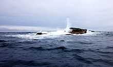
Kolbeinsey


Kolbeinsey (or, Kolbeinn's Isle, Seagull Rock, Mevenklint, Mevenklip, and Meeuw Steen)[1] is a small island 105 kilometres (65 mi) off the northern coast of Iceland, 74 kilometres (46 mi) north-northwest of the island of Grímsey. The island is the northernmost point of Iceland and lies north of the Arctic Circle. A basalt landform, devoid of vegetation, it is subject to rapid wave erosion and is expected to disappear in the near future, probably around the year 2020, based upon current rates of erosion.[2]
The original size of the island is unknown. When it was first measured in 1616, its size was 700 metres (2,300 ft) from north to south and 100 metres (330 ft) east to west. By 1903, it had already diminished to half that size. In August 1985, the size was given as 39 metres (128 ft) across.[2] At the beginning of 2001, Kolbeinsey had reduced to an area of a mere 90 square metres (970 sq ft), which would correspond to the size of a circle of about 7.5 metres (25 ft) in diameter, or the footprint of a residential building. The island has a maximum elevation of 8 metres (26 ft).
A helicopter landing site was constructed on the island in 1989 but efforts to strengthen the island have subsided in part because of agreements with Denmark over limits.[2] It is named after Kolbein Sigmundsson from Kolbeinsdal in Skagafjörður who is said to have broken his ship there and died with his men.
Geology
A submarine eruption was reported in 1372 near the Kolbeinsey Ridge northwest of Grímsey. Kolbeinsey is the only subaerial expression of this portion of the Mid-Atlantic Ridge. It formed during the late-Pleistocene or Holocene. Dredged glass shards indicate submarine eruptive activity during the late-Pleistocene until at least 11,800 radiocarbon years ago.[3]
State of erosion
On 9 March 2006, it was stated that helicopters were no longer able to land on Kolbeinsey.[4] It had been found that almost a half the helipad which was laid with concrete in 1989 had been destroyed when a large piece of rock separated from the rest of the island. Kolbeinsey may disappear completely much sooner than originally expected.[4]
See also
- Extreme points of Iceland
- Geography of Iceland
- List of islands off Iceland
- List of volcanoes in Iceland
- Volcanism in Iceland
References
- ↑ "Kolbeinn's Isle (Kolbeinsey)". wisc.edu. Retrieved 2008-10-28.
- ↑ 2.0 2.1 2.2 Kristján Sæmundsson; Árni Hjartarson (1994). "Geology and erosion of Kolbeinsey". In Gísli Viggóson. Proceedings of the Hornafjörlur International Costal Symposium. Orkustofnun (National Energy Authority of Iceland). pp. 443–451. Retrieved 2008-11-04.
- ↑ "Kolbeinsey Ridge". Global Volcanism Program, Smithsonian Institution. http://www.volcano.si.edu/world/volcano.cfm?vnum=1705-01%3D.
- ↑ 4.0 4.1 "Flag by crash - no longer possible to land helicopters on the island". lhg.is. Retrieved 2010-08-02.
External links
- further information on Kolbeinsey
- Kolbeinsey að hverfa in Icelandic
Coordinates: 67°08′09″N 18°41′03″W / 67.13583°N 18.68417°W
| |||||||