Kolbäcksån
From Wikipedia, the free encyclopedia
| Kolbäcksån | |
| River | |
 | |
| Country | Sweden |
|---|---|
| Mouth | Mälaren |
| - coordinates | 59°30′30″N 16°15′30″E / 59.50833°N 16.25833°E |
| Length | 180 km (112 mi) [1] |
| Basin | 3,100 km2 (1,197 sq mi) [1] |
| Discharge | |
| - average | 27 m3/s (953 cu ft/s) [1] |
 | |
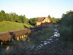
Kolbäcksån is a river located in Bergslagen in the middle of Sweden. It is about 180 kilometres long, arises in the province Dalarna and flows through the province of Västmanland into the Mälaren. The river drains an area of approximately 3.100 km ² and has an average discharge of 27 m³/sec. The city of Fagersta lies on the river and the Strömsholm Canal follows the river about 100 kilometres.
References
- ↑ 1.0 1.1 1.2 "Kolbäcksån". Nationalencyklopedin (in Swedish). Retrieved 14 July 2010. (subscription required)
This article is issued from Wikipedia. The text is available under the Creative Commons Attribution/Share Alike; additional terms may apply for the media files.